
Fountain Creek (Arkansas River)
| Fountain Creek | |
|---|---|

Fountain Creek near Fountain, Colorado
|
|
| Basin features | |
| Main source | 38°59′48″N 105°01′44″W / 38.99667°N 105.02889°W |
| River mouth | Confluence with Arkansas 4,636 ft (1,413 m) 38°15′15″N 104°35′20″W / 38.25417°N 104.58889°WCoordinates: 38°15′15″N 104°35′20″W / 38.25417°N 104.58889°W |
| Progression | Arkansas—Mississippi |
|
|
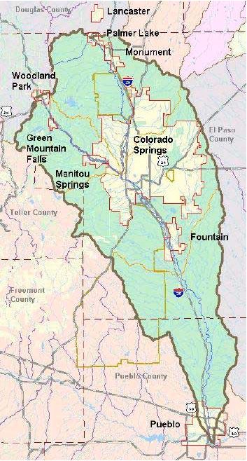
Fountain Creek is a stream that originates in Woodland Park, Teller and flows through El Paso County to Pueblo in Pueblo County, Colorado. The 74.5-mile-long (119.9 km) creek, once known as the Fontaine qui Bouille, is a tributary of the Arkansas River.
The Fountain Creek Watershed—located in Teller, El Paso, and Pueblo counties—is 930 square miles (2,400 km2) in area. Its borders are Pikes Peak, the Palmer Divide and a minor divide east of Colorado Springs.Monument Creek, which originates on Rampart Range, is the main tributary. Other key tributaries are Sand Creek and Jimmy Cap Creek. Fountain Creek and its tributaries flow through Woodland Park, Green Mountain Falls, Palmer Lake, Monument, Manitou Springs, Colorado Springs, and Pueblo.
Fountain Creek's elevation ranges from 14,114 to 4,640 feet (4,302 to 1,414 m) from Pikes Peak to where it meets the Arkansas River in Pueblo. With the significant elevation changes, there are diverse ecosystems and extreme temperature and precipitation variations.
Within the watershed are regional and local parks, including the Fountain Creek Regional Park and Nature Center in Fountain and the Whitewater Kayak Park in Pueblo, and creekside trails that are used for jogging, hiking, bicycle riding, and viewing wildlife.
...
Wikipedia