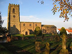
Foston on the Wolds
| Foston on the Wolds | |
|---|---|
 St Andrew's Church, Foston on the Wolds |
|
| Foston on the Wolds shown within the East Riding of Yorkshire | |
| Population | 263 (2011 census) |
| OS grid reference | TA101558 |
| • London | 170 mi (270 km) S |
| Civil parish |
|
| Unitary authority | |
| Ceremonial county | |
| Region | |
| Country | England |
| Sovereign state | United Kingdom |
| Post town | DRIFFIELD |
| Postcode district | YO25 |
| Dialling code | 01262 |
| Police | Humberside |
| Fire | Humberside |
| Ambulance | Yorkshire |
| EU Parliament | Yorkshire and the Humber |
| UK Parliament | |
Foston on the Wolds is a village and civil parish in the East Riding of Yorkshire, England. It is situated approximately 8 miles (13 km) south-west of Bridlington town centre and 2 miles (3 km) north of the village of North Frodingham.
The civil parish is formed by the villages of Foston on the Wolds and Brigham and the hamlet of Gembling. According to the 2011 UK census, Foston on the Wolds parish had a population of 263, an increase on the 2001 UK census figure of 253.
In 1823 Foston inhabitants numbered 300. Occupations included ten farmers, two wheelwrights, two blacksmiths, two grocers who were also drapers, a coal dealer, a corn miller who was also a coal dealer, a boot & shoemaker, a butcher, a tailor, a tanner, and the landlady of the Cross Keys public house. Carriers operated between the village and Hull on Mondays and Thursdays, Driffield and Gembling on Thursdays, and Bridlington on Saturdays. In the village was a Methodist and a Calvinist chapel. The church at the time was dedicated to All Saints.
The village consists largely of a single road running in a north-east to south-west direction, with the buildings grouped on either side. The road continues to the south-west to Bridgham. To the north-east, the road splits into two, one road leading to the hamlet of Gembling, and a second road turning towards the south-east and then the south to reach Beeford. To the west of the village, Foston Beck runs along the western edge of the settlement, while Old Howe Drain runs along the eastern and then the southern edge. Both then turn to the south-west, and join together at Frodingham Bridge, to become part of Frodingham Beck, once part of the Driffield Navigation.
...
Wikipedia

