Bridlington
| Bridlington | |
|---|---|
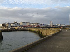
 A view of the town from the harbour entrance |
|
 Arms of Bridlington Town Council |
|
| Bridlington shown within the East Riding of Yorkshire | |
| Population | 35,369 |
| OS grid reference | TA1866 |
| • London | 180 mi (290 km) S |
| Civil parish |
|
| Unitary authority | |
| Ceremonial county | |
| Region | |
| Country | England |
| Sovereign state | United Kingdom |
| Post town | BRIDLINGTON |
| Postcode district | YO15/YO16 |
| Dialling code | 01262 |
| Police | Humberside |
| Fire | Humberside |
| Ambulance | Yorkshire |
| EU Parliament | Yorkshire and the Humber |
| UK Parliament | |
| Website | www.bridlington.gov.uk |
Bridlington is a coastal town and civil parish on the Holderness Coast of the North Sea, situated in the unitary authority and ceremonial county of the East Riding of Yorkshire approximately 24 miles (39 km) north of Hull. The Gypsey Race river runs through the town and emerges into the North Sea in the town harbour. In the 2011 Census the population of the parish was 35,369.
Bridlington is a minor sea fishing port with a working harbour and is well known for its shellfish. It has a mix of small businesses across the manufacturing, retail and service sectors with its prime trade being tourism during the summer months.
The origins of the town are uncertain, but archaeological evidence shows habitation in the Bronze Age and in Roman times. The settlement at the Norman conquest was called Bretlinton, but has also gone by the names of Berlington, Brellington and Britlington, before settling on its modern name in the 19th century.
The town is twinned with Millau in France and Bad Salzuflen in Germany. One of the UK's coastal weather stations is located at Bridlington. The Priory Church of St Mary and the associated Bayle Gate are Grade I listed buildings. The church stands on the site of the original Augustine Priory.
...
Wikipedia

