Fort de Tournoux
| Fort de Tournoux | |
|---|---|
| Part of Alpine Line (backup), Séré de Rivières system | |
| Southeast France | |
 |
|
| Coordinates | 44°28′11″N 6°45′10″E / 44.469722°N 6.752778°E |
| Site information | |
| Owner | Communes of Ubaye |
| Controlled by | France |
| Open to the public |
By appointment |
| Site history | |
| In use | Preserved |
| Materials | Stone, concrete |
| Battles/wars | Italian invasion of France |
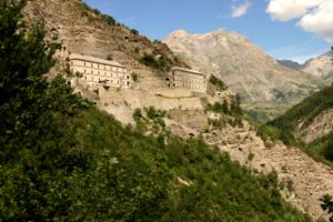
The Fort de Tournoux is a fortification complex in the Ubaye Valley in the French Alps. It was built between 1843 and the early 20th century to defend France against invasion from Italy and Savoy. It was described as the "Military Versailles of the 19th century," resembling a Tibetan monastery on the mountainside above the Ubaye. The fort is actually an ensemble of fortifications, including some "batteries" that rival the main fort in size and power.
Earliest records show that the position of the village of Tournoux was a strategically important one, with the tiny plateau offering food and watering facilities to armies crossing the Col de Larche from modern day Italy and the Col de Vars. There is evidence of Roman occupation of the plateau.
Of later times little survives, but there are the traces of a 7th-century fortified church in the valley. Between the 7th century and the 17th century, the upper Ubaye Valley changed hands between states about 17 times – usually because either the Col de Larche or the Col de Vars became snowless first, and whichever side was nearest was able to march in while the other sat waiting for the snow to melt.
In the 18th century, the valley finally became part of France and the first proper fortifications were built. Three redoubts, of which the Redoubt de Berwick still remains (albeit in modified form), were constructed as shelters for garrisons of soldiers. At the time, the use of cannons was relatively limited and such fighting as there was would have been hand-to-hand or musket-fire only, with the presence of the soldiers being the major deterrent to invasion over the cols.
The Fort de Tournoux is constructed more-or-less continuously up the side of the mountain from 1,300 metres (4,300 ft) altitude to 2,000 metres (6,600 ft) in several levels. The lowest level is the barracks (Caserne Pellegrin) at 1300m next to the main road from the Cols (Larche and Vars) to the village of la Condamine and the towns of Jausiers and Barcelonnette. A battery at this level, built between 1846 and 1862, is called Batterie XII. Linking these with the Fort Moyen ("middle fort", also known as Fort Grouchy) is a road, constructed to allow mules to ascend with carts – so at a maximum gradient of 10% with frequent hairpin turns. The hairpins were constructed so that the mules could park their double-ended carts and run-around to pull the cart in the opposite direction up the next stretch, thus avoiding the need to turn around the hairpin bends, which often caused carts to topple over and spill their contents.
...
Wikipedia

