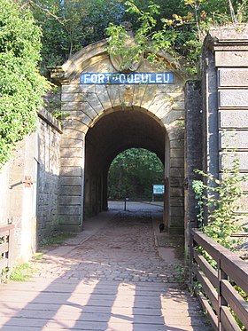
Fort de Queuleu
| Fort de Queuleu | |
|---|---|
| Part of Séré de Rivières system, Fortifications of Metz | |
| France | |
 |
|
| Coordinates | 49°05′44″N 6°12′13″E / 49.09558°N 6.20367°E |
| Type | Fort |
| Site information | |
| Owner | City of Metz |
| Controlled by | France |
| Open to the public |
Yes, surface |
| Condition | Abandoned |
| Site history | |
| Built | 1868 |
| Materials | Brick, stone, concrete |
| Battles/wars | Battle of Metz |
The Fort de Queuleu is a fortification to the southeast of Metz, near Queuleu, France. Construction began while part of Lorraine was under French rule in 1868. After the interruption of the Franco-Prussian War of 1870-71, the fort was improved between 1872 and 1875 by the German Empire, which had annexed the area as a result of the war. Renamed Fort Goeben, it formed part of the first ring of the fortifications of Metz. Functionally obsolete by the First World War, it saw no military action, but was used by the Germans as a detention center for members of the French Resistance during World War II.
The fort was one of the first built according to the fortification system developed by Lieutenant Colonel Raymond Adolphe Séré de Rivières. The goal was to build a discontinuous enclosure around Metz using a series of artillery forts armed with a variety of guns. In the 1860s tension was rising between France and Germany, causing France to attend to the fortification of its frontiers. Metz, close to the border and a strategic road and rail crossing, was the beneficiary of one of the first programs of fortification. Before all of the forts could be completed, France was defeated in the Franco-Prussian War and the area around Metz was annexed to Germany. Metz then became a crucial strongpoint on Germany's frontier, receiving sustained attention to its defenses that culminated in the Moselstellung of the early twentieth century.
The pre-war French construction program comprised eight forts surrounding Metz at a distance of 3.5 - 5.5 km from the center of the city. Planning began in 1864, and in 1867 the project was placed under the supervision of Séré de Rivières. Compared with later Séré de Rivières system forts, the fort's design is reminiscent of the bastioned enclosures of Vauban of the 18th century. In their developed form, the Séré de Rivières forts of the 1870s were much simplified in plan, with less overt reference to historic prototypes.
...
Wikipedia

