Fort Valley, Georgia
| Fort Valley, Georgia | |
|---|---|
| City | |

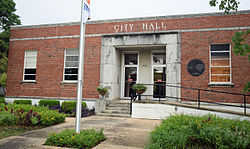
Fort Valley City Hall
|
|
| Nickname(s): "Peach Capital of Georgia" | |
| Motto: "Where Caring Is A Way Of Life" | |
 Location in Peach County and the state of Georgia |
|
| Coordinates: 32°33′N 83°53′W / 32.550°N 83.883°WCoordinates: 32°33′N 83°53′W / 32.550°N 83.883°W | |
| Country | United States |
| State | Georgia |
| County | Peach |
| Area | |
| • Total | 5.3 sq mi (13.6 km2) |
| • Land | 5.3 sq mi (13.6 km2) |
| • Water | 0 sq mi (0 km2) |
| Elevation | 518 ft (158 m) |
| Population (United States Census, 2010) | |
| • Total | 9,815 |
| • Density | 15,123.4/sq mi (15,888.6/km2) |
| Time zone | Eastern (EST) (UTC-5) |
| • Summer (DST) | EDT (UTC-4) |
| ZIP code | 31030 |
| Area code(s) | 478 |
| FIPS code | 13-31096 |
| GNIS feature ID | 0355881 |
| Website | Fort Valley Georgia Website |
Fort Valley is a city in and the county seat of Peach County, Georgia, United States. As of the 2010 census, the city had a population of 9,815.
The city is in the Macon metropolitan area.
The town's name is a mystery, as it has never had a fort. Historians believe that the name was mistakenly changed in a transcription error when the post office was named; the area was originally thought to have been called Fox Valley.
Founded in 1836, Fort Valley was incorporated as a town in 1854 and as a city in 1907. In 1924 Fort Valley was the designated seat of the newly formed Peach County.
Fort Valley was the backdrop for a Life magazine feature story in the March 22, 1943 edition. The World War II-era story focused on the town's sponsoring of the "Ham and Egg Show," a contest held by African-American farmers to highlight ham and poultry production in Peach County, Georgia.
Fort Valley is located at 32°33′N 83°53′W / 32.550°N 83.883°W (32.55, -83.89).
According to the United States Census Bureau, the city has a total area of 5.3 square miles (14 km2), all land.
As of the census of 2000, there were 8,005 people, 3,050 households, and 1,878 families residing in the city. The population density was 1,519.5 people per square mile (586.5/km²). There were 3,303 housing units at an average density of 627.0 per square mile (242.0/km²). The racial makeup of the city was 22.10% White, 74.65% African American, 0.37% Native American, 0.25% Asian, 0.05% Pacific Islander, 1.85% from other races, and 0.72% from two or more races. Hispanic or Latino of any race were 4.37% of the population.
...
Wikipedia
