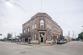
Fort Branch, Indiana
| Fort Branch, Indiana | |
|---|---|
| Town | |
| Town of Fort Branch | |
 |
|
 Location in the state of Indiana |
|
| Coordinates: 38°14′49″N 87°34′34″W / 38.24694°N 87.57611°WCoordinates: 38°14′49″N 87°34′34″W / 38.24694°N 87.57611°W | |
| Country | United States |
| State | Indiana |
| County | Gibson |
| Township | Union |
| Area | |
| • Total | 1.11 sq mi (2.87 km2) |
| • Land | 1.10 sq mi (2.85 km2) |
| • Water | 0.01 sq mi (0.03 km2) |
| Elevation | 449 ft (137 m) |
| Population (2010) | |
| • Total | 2,771 |
| • Estimate (2014) | 2,810 |
| • Density | 2,519.1/sq mi (972.6/km2) |
| Time zone | CST (UTC-6) |
| • Summer (DST) | CDT (UTC-5) |
| ZIP code | 47648 |
| Area code(s) | 812, 930 |
| FIPS code | 18-24250 |
| GNIS feature ID | 0434683 |
| U.S. Highways | |
| Major State Roads | |
Fort Branch is the largest town and second largest community in Gibson County, Indiana after Princeton. The population was 2,771 at the 2010 census. It is part of the Evansville, Indiana, Metropolitan Area
Fort Branch had its start in the year 1852 by the building of the railroad through that territory. The town was originally called LaGrange, for the original owner of the site, but as there was another post office of that same name in Indiana, the town was renamed in commemoration of an old fort.
On February 28, 2017, an EF3 wedge tornado, originating in Crossville, Illinois, passed to the north of the town, destroying or heavily damaging several structures along Indiana 168.
Fort Branch is located at 38°14′49″N 87°34′34″W / 38.24694°N 87.57611°W (38.246872, -87.576003).
According to the 2010 census, Fort Branch has a total area of 1.11 square miles (2.87 km2), of which 1.1 square miles (2.85 km2) (or 99.1%) is land and 0.01 square miles (0.03 km2) (or 0.9%) is water.
As of the census of 2010, there were 2,771 people, 1,162 households, and 774 families residing in the town. The population density was 2,519.1 inhabitants per square mile (972.6/km2). There were 1,244 housing units at an average density of 1,130.9 per square mile (436.6/km2). The racial makeup of the town was 96.8% White, 0.3% African American, 0.1% Native American, 1.2% Asian, 0.6% from other races, and 0.9% from two or more races. Hispanic or Latino of any race were 0.9% of the population.
...
Wikipedia
