Fort Bragg, California
| City of Fort Bragg | |
|---|---|
| City | |

Aerial view of the southern section of Fort Bragg and the mouth of the Noyo River. State Route 1 crosses the river
|
|
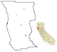
 Location in Mendocino County and the state of California |
|
| Location in the United States | |
| Coordinates: 39°26′45″N 123°48′19″W / 39.44583°N 123.80528°WCoordinates: 39°26′45″N 123°48′19″W / 39.44583°N 123.80528°W | |
| Country |
|
| State |
|
| County | Mendocino |
| Incorporated | August 5, 1889 |
| Area | |
| • Total | 2.782 sq mi (7.207 km2) |
| • Land | 2.749 sq mi (7.120 km2) |
| • Water | 0.033 sq mi (0.086 km2) 1.20% |
| Elevation | 85 ft (26 m) |
| Population (April 1, 2010) | |
| • Total | 7,273 |
| • Estimate (2013) | 7,250 |
| • Density | 2,600/sq mi (1,000/km2) |
| Time zone | Pacific Time Zone (UTC-8) |
| • Summer (DST) | PDT (UTC-7) |
| ZIP code | 95437 |
| Area code | 707 |
| FIPS code | 06-25058 |
| GNIS feature IDs | 1656027, 2410525 |
| Website | city |
| Reference no. | 615 |
| Sister cities |
|---|
| Ōtsuchi, Iwate |
Fort Bragg is a coastal city along State Route 1 in Mendocino County, California. It is 24 miles (39 km) west of Willits, at an elevation of 85 feet (26 m). A California Historical Landmark, the city was founded prior to the American Civil War as a military garrison rather than a fortification. Fort Bragg is a tourist destination because of its picturesque views of the Pacific Ocean. Its population was 7,273 at the 2010 census.
In prehistoric days, the area now known as Fort Bragg was home to the Native Americans, most of whom belonged to the Pomo tribe. They were hunter gatherers who lived along the northern coast of California.
In 1855, an exploration party from the Bureau of Indian Affairs visited the area looking for a site on which to establish a reservation; and, in the spring of 1856, the Mendocino Indian Reservation was established at Noyo. It was 25,000 acres (100 km2), and its boundary extended north from what is now Simpson Lane to Abalobadiah Creek and east from the Pacific Ocean to Bald Hill.
In the summer of 1857, 1st Lt. Horatio G. Gibson, then serving at the Presidio of San Francisco, established a military post on the Reservation, approximately a mile and a half north of the Noyo River, and named it for his former commanding officer Capt. Braxton Bragg, who later became a General in the Army of the Confederacy. The official date of the establishment of the fort was June 11, 1857; and its purpose was to maintain order on the reservation.
...
Wikipedia

