Forest Park (Portland, Oregon)
| Forest Park | |
| Protected Area | |
|
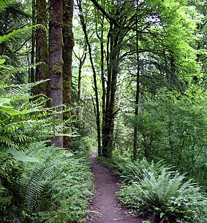
Wildwood Trail in June 2008
|
|
| Name origin: Urban forest reserve | |
| Country | United States |
|---|---|
| State | Oregon |
| City | Portland |
| County | Multnomah |
| Location | Tualatin Mountains (West Hills) |
| - elevation | 718 ft (219 m) |
| - coordinates | 45°32′43″N 122°44′10″W / 45.54528°N 122.73611°WCoordinates: 45°32′43″N 122°44′10″W / 45.54528°N 122.73611°W |
| Highest point | Ridge crest near Northwest Skyline Boulevard |
| - elevation | 1,100 ft (335 m) |
| Lowest point | Ridge base near U.S. Route 30. |
| - elevation | 50 ft (15 m) |
| Area | 5,172.14 acres (2,093 ha) |
| Urban park | 1948 |
| Management | Portland Parks & Recreation Department |
| Open | 5 am to 10 pm |
|
Location of Forest Park and Washington Park in Portland
|
|
Forest Park is a public municipal park in the Tualatin Mountains west of downtown Portland, Oregon, United States. Stretching for more than 8 miles (13 km) on hillsides overlooking the Willamette River, it is one of the country's largest urban forest reserves. The park, a major component of a regional system of parks and trails, covers more than 5,100 acres (2,064 ha) of mostly second-growth forest with a few patches of old growth. About 70 miles (110 km) of recreational trails, including the Wildwood Trail segment of the city's 40 Mile Loop system, crisscross the park.
As early as the 1860s, civic leaders sought to create a natural preserve in the woods near Portland. Their efforts led to the creation of a municipal park commission that in 1903 hired the Olmsted Brothers landscape architectural firm to develop . Acquiring land through donations, transfers from Multnomah County, and delinquent tax foreclosures, the city eventually acted on a proposal by the City Club of Portland and combined parcels totaling about 4,000 acres (1,600 ha) to create the reserve. Formally dedicated in 1948, it ranks 19th in size among parks within U.S. cities, according to The Trust for Public Land.
More than 112 bird species and 62 mammal species frequent the park and its wide variety of trees and shade-loving plants. About 40 inches (1,000 mm) of rain falls on the forest each year. Many small tributaries of the Willamette River flow northeast through the woods to pipes or culverts under U.S. Route 30 at the edge of the park. One of them, Balch Creek, has a resident trout population, and another, Miller Creek, supports sea-run species, including salmon.
...
Wikipedia


