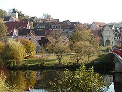
Forchtenberg am Kocher
| Forchtenberg | ||
|---|---|---|
 |
||
|
||
| Coordinates: 49°17′N 9°34′E / 49.283°N 9.567°ECoordinates: 49°17′N 9°34′E / 49.283°N 9.567°E | ||
| Country | Germany | |
| State | Baden-Württemberg | |
| Admin. region | Stuttgart | |
| District | Hohenlohekreis | |
| Municipal assoc. | Mittleres Kochertal | |
| Government | ||
| • Mayor | Michael Foss | |
| Area | ||
| • Total | 38.07 km2 (14.70 sq mi) | |
| Elevation | 223 m (732 ft) | |
| Population (2015-12-31) | ||
| • Total | 4,919 | |
| • Density | 130/km2 (330/sq mi) | |
| Time zone | CET/CEST (UTC+1/+2) | |
| Postal codes | 74670 | |
| Dialling codes | 07947 | |
| Vehicle registration | KÜN | |
| Website | www.forchtenberg.de | |
Forchtenberg is a town in the district of Hohenlohekreis, northern Baden-Württemberg. It lies on the side of a partly fortified hill overlooking the Kocher valley where the Kupfer river flows into the Kocher. The name Forchtenberg is derived from "vor dem Berg" or "before the hill" in English.
Forchtenberg lies on north-facing hill overlooking the Kocher and Kupfer rivers. To the south of Forchtenberg the hills rise higher to woodland and the Hohenlohe plateau beyond. To the north runs the long Kocher valley. Opposite Forchtenberg the hills are a rich tapestry of south-facing vineyards.
Forchtenberg encompasses a number of communities: Forchtenberg itself, Sindringen, Ernsbach, and Muthof. A number of outlying hamlets also fall under the town of Forchtenberg: Büschelhof, Haberhof, Hohensall, Metzdorf, Neuwülfingen, Orbachshof, Rauhbusch, Schießhof, Schleierhof, Schwarzenweiler and Waldfeld.
Forchtenberg was originally established as an offshoot from the hamlet of Wülfingen (which lies on the opposite side of the Kocher river to the hill on which Forchtenberg stands today). According to the wooden plaque found on the cemetery church in Wülfingen, like many settlements in the area near the Limes Romanus, prior to 250 AD the area around Forchtenberg housed a pagan Alemani community. The original Christian church in the old valley site dated back to 536 AD when the settlement fell into the hands of the Franks.
Forchtenberg itself was first mentioned in records in 1298, some 70 years after Count Konrad von Dürn established a fortress on the same hill. The people in Wülfingen, weary of constant flooding from the Kocher river, established the town of Forchtenberg under the fortress on the hill where it stands today. After this, the Valley Church served mainly as a cemetery, as is still the case to this very day. The name Forchtenberg is derived from "vor dem Berg" or "before the hill" in English. On the death of the Count of Dürn the town was reallocated to territory of Hohenlohe. Later, as a result of German Mediatisation, Hohenlohe territories became part of the kingdom of Württemberg. Forchtenberg was allocated to the Oberamt or higher court of Öhringen, which became the District of Öhringen in 1938.
...
Wikipedia


