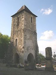
Florimont
| Florimont | |
|---|---|
| Commune | |

Old bell tower
|
|
| Coordinates: 47°30′42″N 7°04′07″E / 47.5117°N 7.0686°ECoordinates: 47°30′42″N 7°04′07″E / 47.5117°N 7.0686°E | |
| Country | France |
| Region | Bourgogne-Franche-Comté |
| Department | Territoire de Belfort |
| Arrondissement | Belfort |
| Canton | Delle |
| Intercommunality | Sud Territoire |
| Government | |
| • Mayor (2014–2020) | Roger Scherrer |
| Area1 | 18.19 km2 (7.02 sq mi) |
| Population (2006)2 | 423 |
| • Density | 23/km2 (60/sq mi) |
| Time zone | CET (UTC+1) |
| • Summer (DST) | CEST (UTC+2) |
| INSEE/Postal code | 90046 /90100 |
| Elevation | 367–505 m (1,204–1,657 ft) |
|
1 French Land Register data, which excludes lakes, ponds, glaciers > 1 km² (0.386 sq mi or 247 acres) and river estuaries. 2Population without double counting: residents of multiple communes (e.g., students and military personnel) only counted once. |
|
1 French Land Register data, which excludes lakes, ponds, glaciers > 1 km² (0.386 sq mi or 247 acres) and river estuaries.
Florimont is a commune in the Territoire de Belfort department in Bourgogne-Franche-Comté in northeastern France.
Florimont, at 384 m, lies 5 km east of Delle and about 21 km southeast the city Belfort (as the crow flies). The village extends in the transient area between the flat country of the Belfort Gap and the northern foothills of the Juras, in the Coeuvatte valley at the north foothills of Florimont, close to the border with Switzerland.
The village that in 1999 had a population of 394, had 398 in 1803. The area is relatively large: 18.19 km ² and extends over a dozen kilometers from north to south. Florimont, which was an important manor in the Middle Ages, incorporated into its territory the disappeared villages of Normanvillars and Saint-Andre-d'Essert.
Saint-André-d'Essert
This village, of which there only remains the farm of Saint-André, one kilometer from Faverois, should not be confused with the city of Essert, near Belfort, although the origin of the name is undoubtedly the same: a cultivable ground reclaimed from the forest. In the seventeenth century Saint-André had a church which would have already existed sometime between 1274 and at least 1466, when a priest officiated there. It was restored in 1606 but was threatened with ruin in 1749. By the end of the eighteenth century all that remained there were four Anabaptist families, and the church disappeared. The hamlet belongs to the parish of Faverois. In texts written in German, Essert is Germanized as Schert.
Normanvillars
Normanvillars was a Mennonite settlement on the border of the Sundgau (southern Alsace) and the Territory of Belfort in a forest area called by that name. It was about 10-15 miles (16-25 km) northeast of Montbéliard, southeast of Belfort, and north of Delle. The settlement was established between 1747 and 1780 by Mennonite families coming from the Swiss Jura to the south and a few Amish families coming from the Montbéliard area to the southwest. By 1791, according to a military census, 23 of the 97 families in the commune of Florimont were Mennonite. By the end of the eighteenth century this rather extended settlement was divided into two organized congregations, both meeting in homes, the one to the north called La Maie (later Belfort), the one in the south called Florimont. The first meetinghouse at Normanvillars, the Chapelle des Fermes, was erected in 1849 after many members had emigrated. The beginning of emigration to North America was in 1819. A number of families settled in Putnam County, Ohio, others in western Waterloo County, Ontario.
...
Wikipedia


