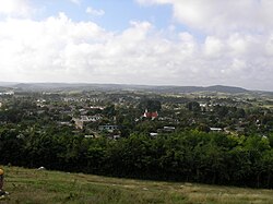
Florencia, Cuba
| Florencia | |
|---|---|
| Municipality | |
 |
|
 Florencia municipality (red) within Ciego de Ávila Province (yellow) and Cuba |
|
| Location of Florencia in Cuba | |
| Coordinates: 22°08′51″N 78°58′1″W / 22.14750°N 78.96694°WCoordinates: 22°08′51″N 78°58′1″W / 22.14750°N 78.96694°W | |
| Country |
|
| Province | Ciego de Ávila |
| Area | |
| • Total | 286 km2 (110 sq mi) |
| Elevation | 110 m (360 ft) |
| Population (2004) | |
| • Total | 19,811 |
| • Density | 69.3/km2 (179/sq mi) |
| Time zone | EST (UTC-5) |
| Area code(s) | +53-336 |
Florencia (Spanish pronunciation: [floˈɾensja]) is a municipality and town in the Ciego de Ávila Province of Cuba. It is located in the western part of the province, south of Chambas. This municipality merged in 1976 as result of the new political and administrative division of Cuba. Florencia was formerly the barrios of Guadalupe, Tamarindo and Marroquí which were separated from the municipality of Moron.
The municipality is a mountain region with rivers, forest and caves with subterranean rivers. A huge hydraulic complex was constructed under Fidel's government in 1991 named "Liberación de Florencia" ("Florencia Independence") since the Florencia area was the first quarter taken by local revolutionary forces in the province of Camagüey on December 14, 1958. This hydraulic complex is located in the fertile valleys of Florencia and Tamarindo and it reinforces the beauty of this Cuban area. Unlike other municipalities in this province, Florencia is the only one where its economy is basically tobacco.
Florencia is also the seat of the municipal government and the biggest city with around 7,000 people. Other towns are Tamarindo, Las Pojas, Lowrey, Guadalupe and Marroquí.
In 1920's the Norte de Cuba railroad opened between the cities of Santa Clara and Puerto Tarafa in Nuevitas (Camagüey). The origin of Florencia was the construction of a railroad station to provide access to its Guadalupe neighbors in 1926. Guadalupe is the oldest town in this region. This train station was built on a farm known as El Merino (on a site called Ojo de Agua (eye of water)). The railroad was crucial for this region, it actually was the first means of communication and transport that linked these lost valleys with the rest of country. In the 1920s the roads were almost nonexistent and people lived in complete isolation. The only method of communication and transport was by arreas (mules). With the arrival of the railroad, the farmers became wealthier and as a result many merchants and businessmen moved their companies to be near the new station. Real estate companies and the local owners of the farms started to develop what is now this enchanting town. First the railroad station and then the new town itself was named Florencia. The name was suggested by one of the neighbors who said that the mountain view reminded her of the mountains near Florence in Italy.
...
Wikipedia

