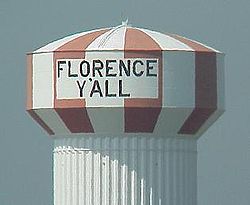
Florence, Kentucky
| Florence, Kentucky | |
|---|---|
| City | |

|
|
 Location within Boone County and the state of Kentucky |
|
| Coordinates: 38°59′36″N 84°38′33″W / 38.99333°N 84.64250°WCoordinates: 38°59′36″N 84°38′33″W / 38.99333°N 84.64250°W | |
| Country | United States |
| State | Kentucky |
| County | Boone |
| Established | 1830 |
| Incorporated | February 17, 1860 |
| Area | |
| • Total | 10.3 sq mi (26.8 km2) |
| • Land | 10.3 sq mi (26.7 km2) |
| • Water | 0.04 sq mi (0.1 km2) |
| Elevation | 925 ft (282 m) |
| Population (2010) | |
| • Total | 29,951 |
| • Density | 2,906/sq mi (1,122.0/km2) |
| Time zone | Eastern (EST) (UTC-5) |
| • Summer (DST) | EDT (UTC-4) |
| ZIP codes | 41022, 41042 |
| Area code(s) | 859 |
| FIPS code | 21-27982 |
| GNIS feature ID | 0492266 |
| Website | www |
Florence is a home rule-class city in Boone County, Kentucky, in the United States. Florence is part of the Cincinnati/Northern Kentucky metropolitan area. The population was 29,951 at the 2010 census.
The Florence area was originally known as Crossroads, because of the convergence of several roads from Burlington and Union at Ridge Road (now U.S. 25). By 1821, the area was known as Maddentown for Thomas Madden, a Covington attorney who owned a farm on the Burlington Pike. When Madden moved away, the area became known as Connersville in 1828 for Jacob Conner, a settler who assumed responsibility for the growing town. The town was finally renamed to Florence owing to another Connersville in Harrison County. The name presumably is a transfer from Florence, Italy, but the specific etymology is unclear. It was incorporated on January 27, 1830, and grew quickly after the completion of the Covington-Lexington Turnpike in 1836.
Florence is located in eastern Boone County at 38°59′36″N 84°38′33″W / 38.99333°N 84.64250°W (38.993225, -84.642602). U.S. Routes 25, 42, and 127 pass through the center of Florence, leading northeast in a concurrency 11 miles (18 km) to downtown Cincinnati. Interstates 75 and 71 pass through the western part of Florence, with access from exits 178 through 182.
...
Wikipedia
