Fleurie
| Fleurie | |
|---|---|
| Commune | |

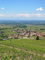
A general view of Fleurie
|
|
| Coordinates: 46°11′35″N 4°41′53″E / 46.193°N 4.698°ECoordinates: 46°11′35″N 4°41′53″E / 46.193°N 4.698°E | |
| Country | France |
| Region | Auvergne-Rhône-Alpes |
| Department | Rhône |
| Arrondissement | Villefranche-sur-Saône |
| Canton | Belleville |
| Government | |
| • Mayor (2008–2014) | Frédéric Miguet |
| Area1 | 13.94 km2 (5.38 sq mi) |
| Population (1999)2 | 1,190 |
| • Density | 85/km2 (220/sq mi) |
| Time zone | CET (UTC+1) |
| • Summer (DST) | CEST (UTC+2) |
| INSEE/Postal code | 69084 /69820 |
| Elevation | 210–524 m (689–1,719 ft) (avg. 300 m or 980 ft) |
|
1 French Land Register data, which excludes lakes, ponds, glaciers > 1 km² (0.386 sq mi or 247 acres) and river estuaries. 2Population without double counting: residents of multiple communes (e.g., students and military personnel) only counted once. |
|
1 French Land Register data, which excludes lakes, ponds, glaciers > 1 km² (0.386 sq mi or 247 acres) and river estuaries.
Fleurie is a commune in the Rhône department in eastern France.
Medieval charters record Fleurie as Floriacum.
Fleurie AOC is a division of the Beaujolais wine region. In the 1970s the British Conservative politician and tax fugitive Ernest Marples (1907–78) owned a Fleurie château and vineyard, to which he retired after fleeing from an Inland Revenue investigation in 1975.
...
Wikipedia


