Fishkill Creek
| Fishkill Creek (Matteawan ) | |
| River | |
|
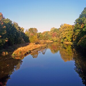
Fishkill Creek from NY 52 near Brinckerhoff
|
|
| Name origin: Dutch for "fish stream" | |
| Country | United States |
|---|---|
| State | New York |
| Region | Hudson Valley |
| County | Dutchess |
| Towns | Union Vale, Beekman, East Fishkill, Fishkill |
| Tributaries | |
| - left | Whaley Lake Brook, Clove Creek |
| - right | Whortlekill Creek, Sprout Creek |
| City | Beacon |
| Source | Pray Pond |
| - elevation | 480 ft (146 m) |
| - coordinates | 41°40′38″N 73°40′38″W / 41.67722°N 73.67722°W |
| Mouth | Hudson River S of Denning Point |
| - elevation | 0 ft (0 m) |
| - coordinates | 41°28′55″N 73°59′8″W / 41.48194°N 73.98556°WCoordinates: 41°28′55″N 73°59′8″W / 41.48194°N 73.98556°W |
| Length | 33.5 mi (54 km), SW |
| Basin | 193 sq mi (500 km2) |
| Discharge | for Beacon |
| - average | 205 cu ft/s (6 m3/s) |
| - max | 6,970 cu ft/s (197 m3/s) August 20, 1955 |
| - min | 1.1 cu ft/s (0 m3/s) September 12, 1964 |
|
Fishkill Creek watershed
|
|
Fishkill Creek is a tributary of the Hudson River in Dutchess County, New York, United States. At 33.5 miles (53.9 km) it is the second longest stream in the county, after Wappinger Creek. It rises in the town of Union Vale and flows generally southwest to a small estuary on the Hudson just south of Beacon. Part of its 193-square-mile (500 km2) watershed is in Putnam County to the south. Sprout Creek, the county's third-longest creek, is its most significant tributary. Whaley and Sylvan lakes and Beacon Reservoir, its largest, deepest and highest lakes, are among the bodies of water within the watershed.
While the creek is not impounded for use in any local water supply, it remains a focus of regional conservation efforts as a recreational and aesthetic resource, especially since the lower Fishkill watershed has been extensively developed in the last two decades. It flows through several local parks and is a popular trout stream. Industries and mills along it helped spur the settlement of the region.
Clove and Sweezy brooks, themselves fed by tributaries named and unnamed draining the steep slopes on either side of the narrow upper Clove Valley in the town of Union Vale, drain the swamps of the valley into Pray Pond just north of the hamlet of Clove. Fishkill Creek is the pond's outflow.
It follows Clove Valley Road (County Route 9) closely at first, flowing almost due south alongside it, then swings westward into woods after receiving Christie Pond's outlet brook opposite Clove Cemetery. At a short loop in a swampy area where Bruzgul Road (County Route 21) crosses twice, it receives another tributary, doubles back to the north around a hill to receive another one and then returns to its southward course to widen into McKinney Pond. Once it crosses Bruzgul Road again, it is in Tymor Park, Union Vale's major community center.
...
Wikipedia


