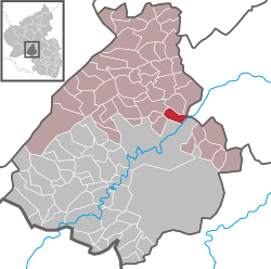
Fischbach, Birkenfeld
| Fischbach | ||
|---|---|---|
|
||
| Coordinates: 49°44′30″N 07°24′05″E / 49.74167°N 7.40139°ECoordinates: 49°44′30″N 07°24′05″E / 49.74167°N 7.40139°E | ||
| Country | Germany | |
| State | Rhineland-Palatinate | |
| District | Birkenfeld | |
| Municipal assoc. | Herrstein | |
| Government | ||
| • Mayor | Michael Hippeli (SPD) | |
| Area | ||
| • Total | 4.00 km2 (1.54 sq mi) | |
| Elevation | 225 m (738 ft) | |
| Population (2015-12-31) | ||
| • Total | 902 | |
| • Density | 230/km2 (580/sq mi) | |
| Time zone | CET/CEST (UTC+1/+2) | |
| Postal codes | 55743 | |
| Dialling codes | 06784 | |
| Vehicle registration | BIR | |
| Website | www.fischbach-nahe.de | |
Fischbach is an Ortsgemeinde – a municipality belonging to a Verbandsgemeinde, a kind of collective municipality – in the Birkenfeld district in Rhineland-Palatinate, Germany. It belongs to the Verbandsgemeinde of Herrstein, whose seat is in the like-named municipality.
The municipality lies in the southern Hunsrück on the river Nahe, near Idar-Oberstein and on the Deutsche Edelsteinstraße (“German Gem Road”). The Fischbach, coming from the Idar Forest, flows through the village.
In 1438, Fischbach had its first documentary mention when the Counts of Sponheim, who until this time had been the local lords, died out. Thereafter, ownership was jointly held by the Margraves of Baden and the Counts of Veldenz. The Veldenzes’ share was taken over in 1444 by Palatinate-Simmern and then in 1559 by Palatinate-Zweibrücken. Within the framework of a territorial swap in 1776, Fischbach became wholly Badish. From 1792 to 1814, the village was part of the French Department of Sarre. After the Congress of Vienna, it ended up with the Principality of Birkenfeld, and thereby with the Duchy of Oldenburg.
...
Wikipedia


