Findlay Township
| Findlay Township, Pennsylvania | |
|---|---|
| Township | |

Aerial view looking southwest over Route 576
|
|
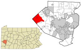
 Location in Allegheny County and state of Pennsylvania |
|
| Coordinates: 40°28′33″N 80°16′59″W / 40.47588°N 80.28313°WCoordinates: 40°28′33″N 80°16′59″W / 40.47588°N 80.28313°W | |
| Country | United States |
| State | Pennsylvania |
| County | Allegheny |
| Government | |
| • Type | Board of Supervisors |
| Area | |
| • Total | 32.39 sq mi (83.89 km2) |
| • Land | 32.38 sq mi (83.87 km2) |
| • Water | 0.01 sq mi (0.01 km2) |
| Elevation | 1,125 ft (343 m) |
| Population (2010) | |
| • Total | 5,060 |
| • Estimate (2016) | 5,638 |
| • Density | 174.10/sq mi (67.22/km2) |
| Time zone | Eastern (EST) (UTC-5) |
| • Summer (DST) | EDT (UTC-4) |
| ZIP code | 15026, 15071, 15108, 15126 |
| Area code(s) | 724 |
| FIPS code | 42-003-25904 |
| Website | Findlay Township |
Findlay Township is a township located west of Pittsburgh in Allegheny County, Pennsylvania, United States. The population was 5,060 at the 2010 census.
The township is the home of Pittsburgh International Airport, which it shares with neighboring Moon Township to the east.
According to the United States Census Bureau, the township has a total area of 32.6 square miles (84 km2), all of it land.
Findlay Township has four borders, including the townships of Moon to the east and northeast, North Fayette to the southeast, Robinson in Washington County to the southwest, and Independence in Beaver County to the northwest.
As of the census of 2000, there were 5,145 people, 2,028 households, and 1,460 families residing in the township. The population density was 157.9 people per square mile (61.0/km²). There were 2,128 housing units at an average density of 65.3/sq mi (25.2/km²). The racial makeup of the township was 96.17% White, 1.63% African American, 0.14% Native American, 1.11% Asian, 0.08% from other races, and 0.87% from two or more races. Hispanic or Latino of any race were 0.56% of the population.
...
Wikipedia
