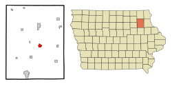
Fayette, Iowa
| Fayette, Iowa | |
|---|---|
| City | |
 Location of Fayette, Iowa |
|
| Location in the United States | |
| Coordinates: 42°50′33″N 91°48′11″W / 42.84250°N 91.80306°WCoordinates: 42°50′33″N 91°48′11″W / 42.84250°N 91.80306°W | |
| Country |
|
| State |
|
| County | Fayette |
| Area | |
| • Total | 1.48 sq mi (3.83 km2) |
| • Land | 1.48 sq mi (3.83 km2) |
| • Water | 0 sq mi (0 km2) |
| Elevation | 1,007 ft (307 m) |
| Population (2010) | |
| • Total | 1,338 |
| • Estimate (2012) | 1,386 |
| • Density | 904.1/sq mi (349.1/km2) |
| Time zone | Central (CST) (UTC-6) |
| • Summer (DST) | CDT (UTC-5) |
| ZIP code | 52142 |
| Area code(s) | 563 |
| FIPS code | 19-27165 |
| GNIS feature ID | 0456562 |
| Website | www.fayetteia.com |
Fayette is a city in Fayette County, Iowa, in the United States. As of the 2010 census, the city population was 1,338. It was named after the Marquis de la Fayette, French hero of the American Revolutionary War. Fayette is the home of Upper Iowa University, a small private college. The Volga River State Recreation Area is located just north of Fayette, and many other parks and natural areas are nearby.
William B. Dohrmann was the mayor for 24 years and ended his term in 2013.
Fayette is located at 42°50′33″N 91°48′11″W / 42.84250°N 91.80306°W (42.842414, -91.803013) on the Volga River.
According to the United States Census Bureau, the city has a total area of 1.48 square miles (3.83 km2), all of it land.
As of the census of 2010, there were 1,338 people, 434 households, and 185 families residing in the city. The population density was 904.1 inhabitants per square mile (349.1/km2). There were 485 housing units at an average density of 327.7 per square mile (126.5/km2). The racial makeup of the city was 88.6% White, 6.7% African American, 1.9% Asian, 0.1% Pacific Islander, 1.0% from other races, and 1.6% from two or more races. Hispanic or Latino of any race were 2.8% of the population.
...
Wikipedia

