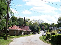
Farmville, Virginia
| Farmville, Virginia | |
|---|---|
| Town | |

Residential area of Farmville
|
|
 Location of Farmville, Virginia |
|
| Coordinates: 37°17′52″N 78°23′45″W / 37.29778°N 78.39583°WCoordinates: 37°17′52″N 78°23′45″W / 37.29778°N 78.39583°W | |
| Country | United States |
| State | Virginia |
| Counties | Prince Edward, Cumberland |
| Government | |
| • Type | Local |
| • Mayor | David Whitus |
| Area | |
| • Total | 7.3 sq mi (19.0 km2) |
| • Land | 7.2 sq mi (18.7 km2) |
| • Water | 0.1 sq mi (0.3 km2) |
| Elevation | 351 ft (107 m) |
| Population (2010) | |
| • Total | 8,216 |
| • Density | 1,140/sq mi (440.3/km2) |
| Time zone | Eastern (EST) (UTC-5) |
| • Summer (DST) | EDT (UTC-4) |
| ZIP codes | 23901, 23909, 23943 |
| Area code(s) | 434 |
| FIPS code | 51-27440 |
| GNIS feature ID | 1498477 |
| Website | www |
| Private | |
| Industry | Coal |
| Founded | (March 24, 1837) |
| Defunct |
1880's |
| Headquarters | Farmville, Virginia |
|
Area served
|
Farmville |
| Website | www |
| Industry | Coal |
|---|---|
| Founded | 1860 in Raines Tavern, Virginia, Virginia, United States |
| Founder | John Dalby |
| Website | www |
| Private | |
| Industry | Coal |
| Founded | (1881) |
| Defunct | |
| Headquarters | Farmville, Virginia |
|
Area served
|
Farmville |
| Website | www |

Farmville Lithia Springs Water Advertisement from Philadelphia
|
|
| Private | |
| Industry | Beverage |
| Fate | Bottling House burned down. |
| Founded | (1884-08-24) |
| Defunct | 1901-07-07 (dissolved) |
| Headquarters | Farmville, Virginia |
|
Area served
|
International |
| Website | www |
Farmville is a town in Prince Edward and Cumberland counties in the U.S. state of Virginia. The population was 8,216 at the 2010 census. It is the county seat of Prince Edward County.
The Appomattox River traverses Farmville, along with the High Bridge Trail State Park, a more than 30-mile-long (48 km) rail trail park. At the intersection of US 15, VA 45 and US 460, Farmville is the home of Longwood University and is the town nearest to Hampden–Sydney College.
Near the headwaters of the Appomattox River, the town of Farmville was formed in 1798 and incorporated in 1912.
Farmville was the end of the line for the Upper Appomattox Canal Navigation System between 1795 until 1890. African Americans built the canal system. Tobacco and farm produce could be loaded into a James River bateau in Farmville and sent to Petersburg, Virginia. The canals were used until railroads became common. Many of the boatmen who worked in the Upper Appomattox Navigation, near Farmville were free people of color, who lived in the Israel Hill community. Israel Hill was home to free African American laborers, craftsmen and farmers freed around 1810, and White people. People of African and European descent worked for the same wages; built a church together and could be defended in court within the 350 acre town.
...
Wikipedia
