Farmington Township, Clarion County, Pennsylvania
| Farmington Township, Clarion County, Pennsylvania |
|
|---|---|
| Township | |

|
|
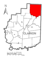
 Map of Clarion County, Pennsylvania highlighting Farmington Township |
|
 Map of Clarion County, Pennsylvania |
|
| Country | United States |
| State | Pennsylvania |
| County | Clarion |
| Incorporated | 1806 |
| Area | |
| • Total | 62.5 sq mi (161.9 km2) |
| • Land | 62.3 sq mi (161.3 km2) |
| • Water | 0.2 sq mi (0.6 km2) |
| Population (2010) | |
| • Total | 1,934 |
| • Density | 31/sq mi (12.0/km2) |
| Time zone | Eastern (EST) (UTC-5) |
| • Summer (DST) | EDT (UTC-4) |
Farmington Township is a township in Clarion County, Pennsylvania, United States. The population was 1,934 at the 2010 census.
The township is located in the northeast corner of Clarion County and is bordered by Forest County to the north and east. A small part of the eastern border of the township touches Jefferson County. The Clarion River forms the southeast border of the township.
According to the United States Census Bureau, the township has a total area of 62.5 square miles (161.9 km2), of which 62.3 square miles (161.3 km2) is land and 0.2 square miles (0.6 km2), or 0.36%, is water.
The unincorporated communities of Tylersburg, Leeper, Crown, and Vowinckel are in the township. Tylersburg is located along Pennsylvania Route 36, Crown and Vowinckel are on Pennsylvania Route 66, and Leeper is at the intersection of the two highways, west of the center of the township. Cook Forest State Park is in the eastern part of the township in the valley of Toms Run, a tributary of the Clarion River.
As of the census of 2000, there were 1,986 people, 818 households, and 561 families residing in the township. The population density was 31.8 people per square mile (12.3/km²). There were 1,750 housing units at an average density of 28.0/sq mi (10.8/km²). The racial makeup of the township was 99.40% White, 0.20% African American, 0.15% Native American, 0.10% Asian, and 0.15% from two or more races. Hispanic or Latino of any race were 0.15% of the population.
...
Wikipedia
