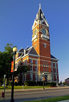
Clarion County, Pennsylvania
| Clarion County, Pennsylvania | ||
|---|---|---|

Clarion County Courthouse
|
||
|
||
 Location in the U.S. state of Pennsylvania |
||
 Pennsylvania's location in the U.S. |
||
| Founded | March 11, 1839 | |
| Seat | Clarion | |
| Largest borough | Clarion | |
| Area | ||
| • Total | 610 sq mi (1,580 km2) | |
| • Land | 601 sq mi (1,557 km2) | |
| • Water | 9.0 sq mi (23 km2), 1.5% | |
| Population (est.) | ||
| • (2015) | 39,498 | |
| • Density | 66/sq mi (25/km²) | |
| Congressional districts | 3rd, 5th | |
| Time zone | Eastern: UTC-5/-4 | |
| Website | www |
|
| Footnotes: | ||
| Designated | April 26, 1982 | |
Clarion County is a county located in the U.S. state of Pennsylvania. As of the 2010 United States Census, the population was 39,988. Its county seat is Clarion. The county was formed on March 11, 1839, from parts of Venango and Armstrong counties. Clarion County is entirely defined as part of the Pittsburgh media market.
According to the U.S. Census Bureau, the county has a total area of 610 square miles (1,600 km2), of which 601 square miles (1,560 km2) is land and 9.0 square miles (23 km2) (1.5%) is water.
Part of Cook Forest State Park is in Clarion County.
The Clarion County Park is located in Paint Township. Clarion County Veterans Memorial Park is located near the Clarion County Courthouse in the center of the Borough of Clarion.
As of the census of 2000, there were 41,765 people, 16,052 households, and 10,738 families residing in the county. The population density was 69 people per square mile (27/km²). There were 19,426 housing units at an average density of 32 per square mile (12/km²). The racial makeup of the county was 98.16% White, 0.79% Black or African American, 0.11% Native American, 0.34% Asian, 0.08% from other races, and 0.52% from two or more races. 0.41% of the population were Hispanic or Latino of any race. 45.0% were of German, 10.3% American, 9.8% Irish, 6.7% Italian and 6.2% English ancestry according to Census 2000.
...
Wikipedia

