Farmington, MO
| Farmington, Missouri | |
|---|---|
| City | |
| Motto: Tradition and Progress | |
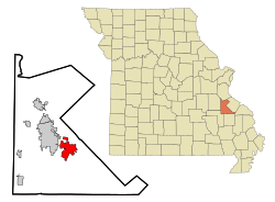
 Location of Farmington, Missouri |
|
| Coordinates: 37°46′55″N 90°25′20″W / 37.78194°N 90.42222°WCoordinates: 37°46′55″N 90°25′20″W / 37.78194°N 90.42222°W | |
| Country | United States |
| State | Missouri |
| County | St. Francois |
| Government | |
| • Type | City council |
| • Mayor | Mit Landrum (R) |
| Area | |
| • Total | 9.39 sq mi (24.32 km2) |
| • Land | 9.35 sq mi (24.22 km2) |
| • Water | 0.04 sq mi (0.10 km2) |
| Elevation | 915 ft (279 m) |
| Population (2010) | |
| • Total | 16,240 |
| • Estimate (2015) | 18,181 |
| • Density | 1,736.9/sq mi (670.6/km2) |
| Time zone | Central (CST) (UTC-6) |
| • Summer (DST) | CDT (UTC-5) |
| Zip Code | 63640 |
| Area code(s) | 573 |
| FIPS code | 29-23752 |
| GNIS feature ID | 0756036 |
| Website | http://farmington-mo.gov |
Farmington is a city in St. Francois County located 72 miles (116 km) southwest of St. Louis in the Lead Belt region in Missouri in the United States. As of the 2010 census, the population was 16,240. It is the county seat of St. Francois County. The Farmington Micropolitan Statistical Area includes St. Francois County and Washington County and has a population of 90,554 as of 2010. Farmington is a component of the St. Louis-St. Charles-Farmington, MO-IL Combined Statistical Area, also known as Greater St. Louis.
Farmington was established in 1822 as Murphy's Settlement, named for William Murphy of Kentucky who first visited the site in 1798. When St. Francois County was organized, the town was briefly called St. Francois Court House and later renamed to Farmington.
Farmington is located at 37°46′55″N 90°25′20″W / 37.78194°N 90.42222°W (37.781932, −90.422145). According to the United States Census Bureau, the city has a total area of 9.39 square miles (24.32 km2), of which, 9.35 square miles (24.22 km2) is land and 0.04 square miles (0.10 km2) is water.
...
Wikipedia
