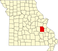
Washington County, Missouri
| Washington County, Missouri | |
|---|---|

Washington County Courthouse
|
|
 Location in the U.S. state of Missouri |
|
 Missouri's location in the U.S. |
|
| Founded | August 21, 1813 |
| Named for | George Washington |
| Seat | Potosi |
| Largest city | Potosi |
| Area | |
| • Total | 762 sq mi (1,974 km2) |
| • Land | 760 sq mi (1,968 km2) |
| • Water | 2.6 sq mi (7 km2), 0.3% |
| Population (est.) | |
| • (2015) | 24,788 |
| • Density | 33/sq mi (13/km²) |
| Congressional district | 8th |
| Time zone | Central: UTC-6/-5 |
| Website | www |
| Washington County, Missouri | ||||
|---|---|---|---|---|
| Elected countywide officials | ||||
| Assessor | Charlotte Boyer | Republican | ||
| Circuit Clerk | Patti Coleman Boyer | Democratic | ||
| County Clerk | Jeannette Allen | Republican | ||
| Collector | Michael P. McGirl | Republican | ||
|
Commissioner (Presiding) |
Marvin Wright | Republican | ||
|
Commissioner (District 1) |
Todd Moyers | Democratic | ||
|
Commissioner (District 2) |
Randy O'Neail | Democratic | ||
| Coroner | Brian Declue | Democratic | ||
| Prosecuting Attorney | John D. Rupp, Jr. | Democratic | ||
| Public Administrator | Janet Drummond | Democratic | ||
| Recorder | Judy Cresswell Moyers | Democratic | ||
| Sheriff | Andy Skiles | Democratic | ||
| Surveyor | R. Timothy Daugherty | Democratic | ||
| Treasurer | Phyllis Long | Republican | ||
| Washington County, Missouri | ||
|---|---|---|
| 2008 Republican primary in Missouri | ||
| John McCain | 616 (38.36%) | |
| Mike Huckabee | 622 (38.73%) | |
| Mitt Romney | 297 (18.49%) | |
| Ron Paul | 50 (3.11%) | |
| Washington County, Missouri | ||
|---|---|---|
| 2008 Democratic primary in Missouri | ||
| Hillary Clinton | 2,345 (74.63%) | |
| Barack Obama | 670 (21.32%) | |
| John Edwards (withdrawn) | 100 (3.18%) | |
Washington County is a county located in the eastern portion of the U.S. state of Missouri. As of the 2010 census, the population was 25,195. The largest city and county seat is Potosi. The county was officially organized on August 21, 1813, and was named in honor of George Washington, the first President of the United States.
The French explorers Renault and La Motte entered the area of present-day Potosi in 1722-23. However, no permanent settlements were made until 1763, when François Breton settled near Potosi and began to operate a mine bearing his name. The Bellview Valley, near Caledonia and Belgrade, was settled in 1802 by the families of Annanias McCoy, Benjamin Crow, and Robert Reed. Washington County was officially organized on August 21, 1813, out of Ste. Genevieve County.
According to the U.S. Census Bureau, the county has a total area of 762 square miles (1,970 km2), of which 760 square miles (2,000 km2) is land and 2.6 square miles (6.7 km2) (0.3%) is water.
As of the census of 2000, there were 23,344 people, 8,406 households, and 6,237 families residing in the county. The population density was 31 people per square mile (12/km²). There were 9,894 housing units at an average density of 13 per square mile (5/km²). The racial makeup of the county was 95.47% White, 2.48% Black or African American, 0.66% Native American, 0.15% Asian, 0.01% Pacific Islander, 0.15% from other races, and 1.08% from two or more races. Approximately 0.73% of the population were Hispanic or Latino of any race.
...
Wikipedia
