Farmersville, California
| Farmersville, California | |
|---|---|
| City | |
| Motto: "The world is quiet here" | |
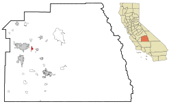
 Location in Tulare County and the state of California |
|
| Location in the United States | |
| Coordinates: 36°18′4″N 119°12′27″W / 36.30111°N 119.20750°WCoordinates: 36°18′4″N 119°12′27″W / 36.30111°N 119.20750°W | |
| Country |
|
| State |
|
| County | Tulare |
| Incorporated | October 5, 1960 |
| Area | |
| • Total | 2.258 sq mi (5.849 km2) |
| • Land | 2.258 sq mi (5.849 km2) |
| • Water | 0 sq mi (0 km2) 0% |
| Elevation | 358 ft (109 m) |
| Population (April 1, 2010) | |
| • Total | 10,588 |
| • Density | 4,700/sq mi (1,800/km2) |
| Time zone | Pacific (UTC-8) |
| • Summer (DST) | PDT (UTC-7) |
| ZIP code | 93223 |
| Area code | 559 |
| FIPS code | 06-23616 |
| GNIS feature IDs | 1652709, 2410485 |
| Website | Official website |
Farmersville is a city in the San Joaquin Valley in Tulare County, California, United States, just to the east of Visalia, California. The population was 10,588 at the 2010 census, up from 8,737 at the 2000 census.
The city hosts many events throughout the year, including a Fall Festival the first weekend in October and a Memorial Day Parade. Both are extremely well-attended and manage to draw visitors from the surrounding areas every Memorial Day morning.
Farmersville is located at 36°18′4″N 119°12′27″W / 36.30111°N 119.20750°W (36.301169, -119.207603).
According to the United States Census Bureau, the city has a total area of 2.3 square miles (6.0 km2), all of it land.
The 2010 United States Census reported that Farmersville had a population of 10,588. The population density was 4,688.2 people per square mile (1,810.1/km²). The racial makeup of Farmersville was 5,295 (50.0%) White, 60 (0.6%) African American, 213 (2.0%) Native American, 72 (0.7%) Asian, 5 (0.0%) Pacific Islander, 4,494 (42.4%) from other races, and 449 (4.2%) from two or more races. Hispanic or Latino of any race were 8,876 persons (83.8%).
...
Wikipedia

