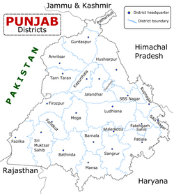
Faridkot, Punjab
|
Faridkot ਫ਼ਰੀਦਕੋਟ |
|
|---|---|
| D | |
 |
|
| Coordinates: 30°24′N 74°27′E / 30.40°N 74.45°ECoordinates: 30°24′N 74°27′E / 30.40°N 74.45°E | |
| Country | India |
| State | Punjab |
| District | Faridkot |
| Founded by | Raja Mokalsi |
| Named for | Baba Farid |
| Government | |
| • Type | Municipal Council |
| • Deputy Commissioner | Rajiv Prashar IAS |
| Area | |
| • Total | 18.14 km2 (7.00 sq mi) |
| Elevation | 196 m (643 ft) |
| Population (2011) | |
| • Total | 87,695 |
| Demonym(s) | Faridkotian, Faridkotiya |
| Languages | |
| • Official | Punjabi |
| Time zone | IST (UTC+5:30) |
| PIN | 151203 |
| Telephone code | +91-1639 |
| Vehicle registration | PB-04 |
| Sex ratio | 1000/890 ♂/♀ |
| Literacy | 72% |
| Website | www |
Faridkot (Punjabi: ) is a city in the south-western Punjab, India. It is the headquarters of the Faridkot district. The Faridkot District was a part of the erstwhile Ferozepur Division but in the year 1996, Faridkot Division was established with a Divisional headquarter at Faridkot which includes Faridkot, Bathinda and Mansa districts.
The city is named in the honor of Baba Farid, who was a revered Sufi saint of the 13th century. The town of Faridkot was founded during this century as Mokalhar by Raja Mokalsi, the grandson of Rai Munj, a Bhatti Chief of Bhatnair, Rajasthan. According to a popular folklore, the Raja renamed Mokalhar to Faridkot after Baba Farid paid a visit to the town. It remained the capital during the reign of Mokalsi’s son Jairsi and Wairsi.
Prior to independence, a large part of the district was under the rule of the Maharaja of Faridkot and later it became a part of the Patiala & East Punjab States Union (PEPSU) in 1948. Faridkot was carved out as a separate district on 7 August 1972 out of the areas of erstwhile Bathinda District (Faridkot Tehsil) and Ferozepur District (Moga and Muktsar Tehsils). Further, in November 1995 the Faridkot District was trifurcated when two of its sub divisions viz. Muktsar and Moga were given the status of independent districts.
The Municipal Council Faridkot came into existence in the year 1948 and now has a Class -I status. Uma Grover is the current President of the council.
The average elevation is 196 metres (643 ft). The town is located on the Punjab Plains, which in a macro regional context forms a part of greater Satluj Ganga plain. It is a low-lying flat area. The surface of the district is depositional plain which was formed by alleviation by the rivers flowing in these plains. Sirhind feeder and Indira Gandhi Canal passes through the district. The topography of the district is plain, with only 1.4% of its area under forest cover.
...
Wikipedia


