Fairview Park, Indiana
| Fairview Park | |
|---|---|
| Town | |
 Vermillion County's location in Indiana |
|
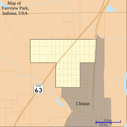
 Map of Fairview Park |
|
| Fairview Park's location in Vermillion County | |
| Coordinates: 39°40′54″N 87°24′49″W / 39.68167°N 87.41361°WCoordinates: 39°40′54″N 87°24′49″W / 39.68167°N 87.41361°W | |
| Country | United States |
| State | Indiana |
| County | Vermillion |
| Township | Clinton |
| Area | |
| • Total | 0.88 sq mi (2.28 km2) |
| • Land | 0.88 sq mi (2.28 km2) |
| • Water | 0 sq mi (0 km2) |
| Elevation | 512 ft (156 m) |
| Population (2010) | |
| • Total | 1,386 |
| • Estimate (2012) | 1,375 |
| • Density | 1,575.0/sq mi (608.1/km2) |
| Time zone | EST (UTC-5) |
| • Summer (DST) | EST (UTC-5) |
| ZIP code | 47842 |
| Area code(s) | 765 |
| FIPS code | 18-22576 |
| GNIS feature ID | 434349 |
| Website | fpi |
Fairview Park is a town in Clinton Township, Vermillion County, Indiana, United States. The population was 1,386 at the 2010 census.
Fairview Park was platted in 1902.
Fairview Park is located in the southeastern part of the county, at the north end of the city of Clinton. Indiana State Road 63 passes through the town from northeast to southwest.
According to the 2010 census, Fairview Park has a total area of 0.88 square miles (2.28 km2), all land.
The climate in this area is characterized by hot, humid summers and generally mild to cool winters. According to the Köppen Climate Classification system, Fairview Park has a humid subtropical climate, abbreviated "Cfa" on climate maps.
As of the census of 2010, there were 1,386 people, 609 households, and 406 families residing in the town. The population density was 1,575.0 inhabitants per square mile (608.1/km2). There were 676 housing units at an average density of 768.2 per square mile (296.6/km2). The racial makeup of the town was 98.2% White, 0.1% African American, 0.1% Native American, 0.2% Asian, 0.1% Pacific Islander, 0.6% from other races, and 0.5% from two or more races. Hispanic or Latino of any race were 0.8% of the population.
...
Wikipedia

