Fairview, Dublin
|
Fairview Fionnradharc
|
|
|---|---|
| Suburb | |

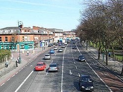
Fairview pictured from the pedestrian bridge, with the park located to the right
|
|
| Location in Ireland | |
| Coordinates: 53°21′54″N 6°13′48″W / 53.365°N 6.23°WCoordinates: 53°21′54″N 6°13′48″W / 53.365°N 6.23°W | |
| Country | Ireland |
| Province | Leinster |
| County | Dublin |
| Elevation | 4 m (13 ft) |
| Time zone | WET (UTC+0) |
| • Summer (DST) | IST (WEST) (UTC-1) |
Fairview (Irish: Fionnradharc) is a coastal suburb of Dublin in Ireland, in the jurisdiction of Dublin City Council. Part of the area forms Fairview Park on land reclaimed from the sea.
Fairview is reached on a main road artery from Dublin city via North Strand, which continues on as the Malahide, Howth and Clontarf Roads. It is served by the Clontarf Road DART station. The area can also be reached by way of several Dublin Bus routes from the city centre, including 14, 15, 27/ABNX, 29A/N, 31/B, 32/ABX, 42/N, 43, 123, and 130.
Neighbouring districts include Marino to the north, North Strand and Ballybough to the west, East Wall to the southwest, and Clontarf to the east.
Fairview is a parish in the Fingal South East deanery of the Roman Catholic Archdiocese of Dublin. It is served by the Church of Visitation of the Blessed Virgin Mary.
The Irish name seen on street signs opposite Fairview Park, as well as on Fairview Avenue and Fairview Terrace, is Baile Bocht, rather than the current Fionnradharc, which suggests that this area was originally part of Ballybough, the neighbouring community on the far side of the river Tolka.
Fairview began to grow after the building of Annesley Bridge in 1797 opened up easy access to the land; since 1488 there had been no crossing of the River Tolka below Ballybough Bridge.
...
Wikipedia

