Fairdale, North Dakota
| Fairdale, North Dakota | |
|---|---|
| City | |

Post office in Fairdale
|
|
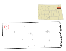
 Location of Fairdale, North Dakota |
|
| Coordinates: 48°29′22″N 98°13′55″W / 48.48944°N 98.23194°WCoordinates: 48°29′22″N 98°13′55″W / 48.48944°N 98.23194°W | |
| Country | United States |
| State | North Dakota |
| County | Walsh |
| Area | |
| • Total | 0.31 sq mi (0.80 km2) |
| • Land | 0.31 sq mi (0.80 km2) |
| • Water | 0 sq mi (0 km2) |
| Elevation | 1,617 ft (493 m) |
| Population (2010) | |
| • Total | 38 |
| • Estimate (2014) | 37 |
| • Density | 122.6/sq mi (47.3/km2) |
| Time zone | Central (CST) (UTC-6) |
| • Summer (DST) | CDT (UTC-5) |
| ZIP code | 58229 |
| Area code(s) | 701 |
| FIPS code | 38-25180 |
| GNIS feature ID | 1028922 |
Fairdale is a city in Walsh County, North Dakota, United States. The population was 38 at the 2010 census. Fairdale was founded in 1905.
Fairdale is located at 48°29′22″N 98°13′55″W / 48.48944°N 98.23194°W (48.489485, -98.231936).
According to the United States Census Bureau, the city has a total area of 0.31 square miles (0.80 km2), all of it land.
As of the census of 2010, there were 38 people, 19 households, and 11 families residing in the city. The population density was 122.6 inhabitants per square mile (47.3/km2). There were 33 housing units at an average density of 106.5 per square mile (41.1/km2). The racial makeup of the city was 92.1% White, 2.6% Asian, and 5.3% from other races. Hispanic or Latino of any race were 5.3% of the population.
There were 19 households of which 5.3% had children under the age of 18 living with them, 52.6% were married couples living together, 5.3% had a female householder with no husband present, and 42.1% were non-families. 36.8% of all households were made up of individuals and 10.5% had someone living alone who was 65 years of age or older. The average household size was 2.00 and the average family size was 2.55.
...
Wikipedia
