Etobicoke North
|
|
|||
|---|---|---|---|

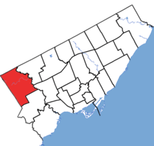
Etobicoke North in relation to other electoral districts in Toronto (2013 boundaries)
|
|||
| Federal electoral district | |||
| Legislature | House of Commons | ||
| MP |
Liberal |
||
| District created | 1976 | ||
| First contested | 1979 | ||
| Last contested | 2015 | ||
| District webpage | profile, map | ||
| Demographics | |||
| Population (2011) | 117,601 | ||
| Electors (2015) | 67,544 | ||
| Area (km²) | 51 | ||
| Pop. density (per km²) | 2,305.9 | ||
| Census divisions | Toronto | ||
| Census subdivisions | Toronto | ||
Etobicoke North (French: Etobicoke-Nord) is a federal electoral district in Toronto, Ontario, Canada, that has been represented in the House of Commons of Canada since 1979. It covers the neighbourhood of Rexdale, in the northern part of the Etobicoke district of Toronto.
The riding was created in 1976 from parts of Etobicoke and York West. In the House of Commons, the riding has been represented by Liberal Kirsty Duncan since 2008.
The riding consists of the northwestern part of the City of Toronto. The eastern boundary is the Humber River East Branch and the Humber River from Steeles Avenue West south to a point just to the east of the Dixon Road. The southern boundary runs west from the Humber River along Dixon Road to Martin Grove Road to Eglinton Avenue to the western limit of the city. The western and northern limits of the ridings are formed by the city limits.
In addition to Rexdale, the riding also contains the neighbourhoods of The Elms, Humberwood, Kingsview Village, Thistletown, and Willowridge.
This riding gained territory from Etobicoke Centre during the 2012 electoral redistribution.
...
Wikipedia
