Etobicoke, Toronto
| Etobicoke | |
|---|---|
| Administrative district | |

Etobicoke's central skyline in 2009
|
|
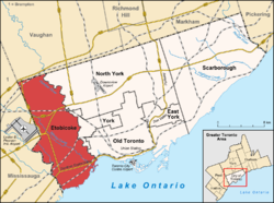
 Location of Etobicoke (red) compared to the rest of Toronto. |
|
| Coordinates: 43°36′58″N 79°30′45″W / 43.61611°N 79.51250°WCoordinates: 43°36′58″N 79°30′45″W / 43.61611°N 79.51250°W | |
| Country |
|
| Province |
|
| Municipality |
|
| Incorporated | 1 January 1850 (township) 1 January 1967 (borough) June 1983 (city) |
| Changed Region | 1954 |
| Amalgamated | 1 January 1998 into Toronto |
| Government | |
| • Councillors |
Ward councillors
|
| • MPs |
Federal reps
|
| • MPPs |
Provincial reps
|
| Area | |
| • Total | 123.93 km2 (47.85 sq mi) |
| Population (2011) | |
| • Total | 347,948 |
| • Density | 2,728.3/km2 (7,066/sq mi) |
| Demonym(s) | Etobian |
| Time zone | EST (UTC-5) |
| • Summer (DST) | EDT (UTC-4) |
| Postal code span | M8V-M9C, M9P-M9R, M9V-M9W |
| Area code(s) | 416, 647 |
Etobicoke ![]() i/ɛˈtoʊbᵻkoʊ/ (with a silent 'ke') is an administrative district and former municipality within the western part of the city of Toronto, Ontario, Canada. Etobicoke was first settled by Europeans in the 1790s; the municipality grew into city status in the 20th century. Several independent villages and towns developed within the area of Etobicoke, only to be absorbed later into Etobicoke during the era of Metro Toronto. Etobicoke was dissolved in 1998, when it was amalgamated with other Metro Toronto municipalities into the City of Toronto. Etobicoke is bordered on the south by Lake Ontario, on the east by the Humber River, on the west by Etobicoke Creek, the city of Mississauga, and Toronto Pearson International Airport (a small portion of the airport extends into Etobicoke), and on the north by Steeles Avenue West.
i/ɛˈtoʊbᵻkoʊ/ (with a silent 'ke') is an administrative district and former municipality within the western part of the city of Toronto, Ontario, Canada. Etobicoke was first settled by Europeans in the 1790s; the municipality grew into city status in the 20th century. Several independent villages and towns developed within the area of Etobicoke, only to be absorbed later into Etobicoke during the era of Metro Toronto. Etobicoke was dissolved in 1998, when it was amalgamated with other Metro Toronto municipalities into the City of Toronto. Etobicoke is bordered on the south by Lake Ontario, on the east by the Humber River, on the west by Etobicoke Creek, the city of Mississauga, and Toronto Pearson International Airport (a small portion of the airport extends into Etobicoke), and on the north by Steeles Avenue West.
...
Wikipedia
