Estherville, Iowa
| Estherville, Iowa | |
|---|---|
| City | |

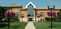
Public Library Estherville, Iowa
|
|
 Location of Estherville, Iowa |
|
| Coordinates: 43°24′16″N 94°50′1″W / 43.40444°N 94.83361°WCoordinates: 43°24′16″N 94°50′1″W / 43.40444°N 94.83361°W | |
| Country |
|
| State |
|
| County | Emmet |
| Area | |
| • Total | 5.32 sq mi (13.78 km2) |
| • Land | 5.32 sq mi (13.78 km2) |
| • Water | 0 sq mi (0 km2) |
| Elevation | 1,296 ft (395 m) |
| Population (2010) | |
| • Total | 6,360 |
| • Estimate (2012) | 6,221 |
| • Density | 1,195.5/sq mi (461.6/km2) |
| Time zone | Central (CST) (UTC-6) |
| • Summer (DST) | CDT (UTC-5) |
| ZIP code | 51334 |
| Area code(s) | 712 |
| FIPS code | 19-25860 |
| GNIS feature ID | 0456397 |
| Website | http://www.cityofestherville.org |
Estherville is a city in Emmet County, Iowa, United States. The population was 6,360 in the 2010 census, a decline from 6,656 in the 2000 census. It is the county seat of Emmet County. Estherville is home to the main campus of Iowa Lakes Community College.
Estherville was laid out in the late 1850s, and the town was incorporated in 1881. The city was named after Esther A. Ridley, one of the first white female settlers in the area.
Estherville Lincoln Central Community School District will open the 2016-2017 school year with the elementary, middle, and high schools on a single campus. This is the final stage of a plan which has seen the construction of new elementary and middle school buildings as well as renovation of the high school. The district is in the process of implementing 1:1 technology, beginning with Chromebooks for all high school students during the 2015-2016 school year.
The recently completed Regional Wellness Center was a joint project of Estherville Lincoln Central Community School District and the National Guard. Beyond standard gym equipment, the facility boasts an indoor track, pools with slides, and multiple group fitness classes.
Estherville Iowa is home to a beautifully restored Carnegie Library. Library services include free public wireless internet.
The intersection of Iowa Highways 4 and 9 features a statue of the Estherville meteorite breaking up in flight.
Fort Defiance State Park offers a variety of trails and outdoor meeting areas. Another park along the West Fork Des Moines River offers popular fishing spots, a historic swinging footbridge, a walking trail, and the community outdoor pool.
Estherville's longitude and latitude coordinates in decimal form are 43.404375, -94.833592.
According to the United States Census Bureau, the city has a total area of 5.32 square miles (13.78 km2), all of it land.
...
Wikipedia
