Eskilstuna
| Eskilstuna | |
|---|---|

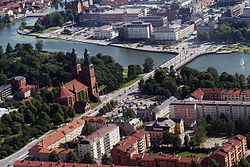
Aerial photo of Eskilstuna in 2004.
|
|
| Coordinates: 59°21′59″N 16°30′30″E / 59.36639°N 16.50833°ECoordinates: 59°21′59″N 16°30′30″E / 59.36639°N 16.50833°E | |
| Country |
|
| Province | Södermanland |
| County | Södermanland County |
| Municipality | Eskilstuna Municipality |
| Founded | 1659 |
| Area | |
| • Total | 31.05 km2 (11.99 sq mi) |
| Elevation | 26 m (85 ft) |
| Population (2015) | |
| • Total | 67 359 |
| • Density | 2,083/km2 (5,390/sq mi) |
| Time zone | CET (UTC+1) |
| • Summer (DST) | CEST (UTC+2) |
| Postal code | 630 03 to 638 21 |
| Area code(s) | (+46) 16 |
| Website | Official website |
Eskilstuna (Swedish pronunciation: [²ɛskɪlsˌtʉːna]) is a city and the seat of Eskilstuna Municipality, Södermanland County, Sweden. The city of Eskilstuna had 67 359 inhabitants in 2015, with a total municipal population of 100,092 inhabitants in Eskilstuna municipality (2014). Eskilstuna has a large Sweden Finn population. The town is located on the River Eskilstunaån, which connects Lake Hjälmaren and Lake Mälaren.
Eskilstuna's history dates back to medieval times when English monk Saint Eskil made "Tuna" his base and diocese of the South coast of Lake Mälaren. Saint Eskil was stoned to death by the pagan vikings of neighbouring town Strängnäs, 30 kilometres (19 miles) east of Eskilstuna, trying to convert them to Christianity. Saint Eskil was buried in his monastery church in Tuna. Later the pagan city of Strängnäs was Christianised and was given the privilege of becoming diocese of South Lake Mälaren. Later "Eskil" was added in to the word "Tuna". However, the town of Eskilstuna did not receive municipal privileges due to its proximity to the medieval city of Torshälla. The monastery of Saint Eskil was completely destroyed by Swedish king Gustav Vasa during the Protestant Reformation and was replaced with the royal castle of Eskilstuna House. The city's first city privileges were granted in 1659, and its boundaries included Tunafors and the newly founded town of Karl Gustavs Stad ("City of Karl Gustav"), located on the west side of the river. Karl Gustavs Stad was built around the iron forges of master smith Reinhold Rademacher, encouraged by King Karl X Gustav. The first products of the forges were small arms and artillery.
...
Wikipedia


