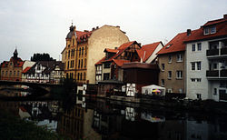
Eschwege, Germany
| Eschwege | ||
|---|---|---|

Eschwege at river Werra.
|
||
|
||
| Coordinates: 51°11′17″N 10°3′10″E / 51.18806°N 10.05278°ECoordinates: 51°11′17″N 10°3′10″E / 51.18806°N 10.05278°E | ||
| Country | Germany | |
| State | Hesse | |
| Admin. region | Kassel | |
| District | Werra-Meißner-Kreis | |
| Government | ||
| • Mayor | Alexander Heppe (CDU) | |
| Area | ||
| • Total | 63.27 km2 (24.43 sq mi) | |
| Elevation | 211 m (692 ft) | |
| Population (2015-12-31) | ||
| • Total | 19,542 | |
| • Density | 310/km2 (800/sq mi) | |
| Time zone | CET/CEST (UTC+1/+2) | |
| Postal codes | 37269 | |
| Dialling codes | 05651 | |
| Vehicle registration | ESW | |
| Website | www.eschwege.de | |
Eschwege (German pronunciation: [ˈɛʃveːɡə]), the district seat of the Werra-Meißner-Kreis, is a town in northeastern Hesse, Germany. In 1971, the town hosted the eleventh Hessentag state festival.
The town lies on a broad plain tract of the river Werra at the foot of the Leuchtberg (mountain) northwest of the Schlierbachswald (range) and east of the Hoher Meißner. The valley basin where the town is located includes a series of small lakes along the northern side of the river.
The nearest city in Hesse is Kassel (roughly 52 km to the northwest), and the nearest in Lower Saxony is Göttingen (roughly 55 km to the north). It lies more or less in the geographical centre of Germany.
Eschwege borders in the north on the town of Bad Sooden-Allendorf and the community of Meinhard, in the east on the town of Wanfried (all three in the Werra-Meißner-Kreis), in the southeast on the town of Treffurt (in Thuringia’s Wartburgkreis), in the south on the communities of Weißenborn and Wehretal, in the west on the community of Meißner, and in the northwest on the community of Berkatal (all four in the Werra-Meißner-Kreis).
Eschwege’s Stadtteile, besides the main town, also called Eschwege, are Albungen, Eltmannshausen, Niddawitzhausen, Niederdünzebach, Niederhone, Oberdünzebach and Oberhone.
...
Wikipedia


