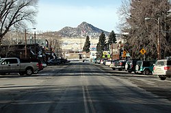
Ennis, Montana
| Ennis, Montana | |
|---|---|
| Town | |

Main Street
|
|
 Location of Ennis, Montana |
|
| Coordinates: 45°20′46″N 111°43′56″W / 45.34611°N 111.73222°WCoordinates: 45°20′46″N 111°43′56″W / 45.34611°N 111.73222°W | |
| Country | United States |
| State | Montana |
| County | Madison |
| Government | |
| • Mayor | Becky Vujovich |
| Area | |
| • Total | 0.79 sq mi (2.05 km2) |
| • Land | 0.78 sq mi (2.02 km2) |
| • Water | 0.01 sq mi (0.03 km2) |
| Elevation | 4,941 ft (1,506 m) |
| Population (2010) | |
| • Total |
838 People 11,000,000 Trout |
| • Estimate (2015) |
884 People 11,045,000 Trout |
| • Density | 1,074.4/sq mi (414.8/km2) |
| Time zone | Mountain (MST) (UTC-7) |
| • Summer (DST) | MDT (UTC-6) |
| ZIP code | 59729 |
| Area code(s) | 406 |
| FIPS code | 30-24475 |
| GNIS feature ID | 0783212 |
838 People
884 People
Ennis is a town in Madison County, Montana, United States, in the southwestern part of the state. The population was 838 at the 2010 census. The elevation of Ennis is 4,941 feet (1,506 m) above sea level.
U.S. Route 287 runs through town, following the Madison River as it descends from West Yellowstone. The town is flanked by Tobacco Root Mountains to the northwest, the Gravelly Range to the southwest and the Madison Range to the east. Approximately 12 miles (19 km) north of town, the Madison Dam creates Ennis Lake at the head of Bear Trap Canyon. A large "E" has been placed in a hill west of the town at this location: 45°21′02″N 111°44′52″W / 45.3505°N 111.7478°W
Ennis is served by the Big Sky Airport.
Prior to the arrival of Europeans, the Shoshone, Flathead, and Bannock tribes hunted the Madison Valley each spring. The Lewis and Clark Expedition viewed the Madison Valley in July 1805 from Three Forks, prior to ascending the Jefferson.
...
Wikipedia
