Enchanted Rock
| Enchanted Rock | |
|---|---|

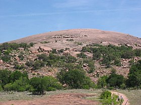
Enchanted Rock, as seen from the trail leading to its summit on a busy hiking day.
|
|
| Highest point | |
| Elevation | 1,825 ft (556 m) |
| Coordinates | 30°30′24″N 98°49′08″W / 30.5065789°N 98.8189305°WCoordinates: 30°30′24″N 98°49′08″W / 30.5065789°N 98.8189305°W |
| Geography | |
| Location | Llano County, Texas, US |
| Geology | |
| Mountain type | granite dome |
| Designated | 1971 |
Enchanted Rock (16710 Ranch Rd 965, Fredericksburg TX) is an enormous pink granite pluton batholith located in the Llano Uplift approximately 17 miles (27 km) north of Fredericksburg, Texas and 24 miles (39 km) south of Llano, Texas, United States. Enchanted Rock State Natural Area, which includes Enchanted Rock and surrounding land, spans the border between Gillespie County and Llano County, south of the Llano River. Enchanted Rock covers approximately 640 acres (260 ha) and rises approximately 425 feet (130 m) above the surrounding terrain to elevation of 1,825 feet (556 m) above sea level. It is the largest such pink granite monadnock in the United States. Enchanted Rock State Natural Area, a part of the Texas state park system, includes 1,644 acres (665 ha). Designated a Recorded Texas Historic Landmark in 1936.
The prominent granite dome is visible for many miles in the surrounding basin of the Llano Uplift. The weathered dome, standing above the surrounding plain is known to geologists as a monadnock. The rock is actually the visible above-ground part of a segmented ridge, the surface expression of a large igneous batholith, called the Town Mountain Granite of middle Precambrian (1,082 ± 6 million years ago) material that intruded into earlier metamorphic schist, called the Packsaddle Schist. The intrusive granite of the rock mass, or pluton, was exposed by extensive erosion of the surrounding sedimentary rock, primarily the Cretaceous Edwards limestone, which is exposed a few miles to the south of Enchanted Rock.
...
Wikipedia

