Elmendorf, Texas
| Elmendorf, Texas | |
|---|---|
| City | |
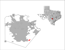
 Location of Elmendorf, Texas |
|
 |
|
| Coordinates: 29°15′25″N 98°20′0″W / 29.25694°N 98.33333°WCoordinates: 29°15′25″N 98°20′0″W / 29.25694°N 98.33333°W | |
| Country | United States |
| State | Texas |
| County | Bexar |
| Area | |
| • Total | 4.50 sq mi (11.66 km2) |
| • Land | 4.48 sq mi (11.60 km2) |
| • Water | 0.02 sq mi (0.06 km2) |
| Elevation | 499 ft (152 m) |
| Population (2010) | |
| • Total | 1,488 |
| • Density | 332/sq mi (128.2/km2) |
| Time zone | Central (CST) (UTC-6) |
| • Summer (DST) | CDT (UTC-5) |
| ZIP code | 78112 |
| Area code(s) | 210, 726 (planned) |
| FIPS code | 48-23272 |
| GNIS feature ID | 1356993 |
Elmendorf is a city in Bexar County, Texas, United States. It is part of the San Antonio—New Braunfels Metropolitan Statistical Area. The population was 1,488 at the 2010 census. It was founded in 1885 and named after Henry Elmendorf, a former mayor of San Antonio. For a long time, the biggest employer was Star Clay Products.
Elmendorf is located in southeastern Bexar County at 29°15′41″N 98°19′50″W / 29.26139°N 98.33056°W (29.261357, -98.330547), 17 miles (27 km) southeast of downtown San Antonio at the juncture of Farm Road 327 and the Southern Pacific Railroad. A small portion of Elmendorf extends to the southeast into Wilson County.
According to the United States Census Bureau, the city has a total area of 4.5 square miles (11.7 km2), of which 0.023 square miles (0.06 km2), or 5.00%, is water.
As of the census of 2000, there were 664 people, 226 households, and 162 families residing in the city. The population density was 537.4 people per square mile (206.8/km²). There were 266 housing units at an average density of 215.3/sq mi (82.8/km²). The racial makeup of the city was 65.81% White, 0.75% African American, 1.05% Native American, 0.15% Asian, 28.46% from other races, and 3.77% from two or more races. Hispanic or Latino of any race were 74.10% of the population.
...
Wikipedia
