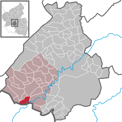
Ellweiler
| Ellweiler | ||
|---|---|---|
|
||
| Coordinates: 49°36′54″N 7°08′40″E / 49.61500°N 7.14444°ECoordinates: 49°36′54″N 7°08′40″E / 49.61500°N 7.14444°E | ||
| Country | Germany | |
| State | Rhineland-Palatinate | |
| District | Birkenfeld | |
| Municipal assoc. | Birkenfeld | |
| Government | ||
| • Mayor | Hans-Robert Spreier | |
| Area | ||
| • Total | 7.46 km2 (2.88 sq mi) | |
| Elevation | 358 m (1,175 ft) | |
| Population (2015-12-31) | ||
| • Total | 293 | |
| • Density | 39/km2 (100/sq mi) | |
| Time zone | CET/CEST (UTC+1/+2) | |
| Postal codes | 55765 | |
| Dialling codes | 06782 | |
| Vehicle registration | BIR | |
| Website | www.ellweiler.de | |
Ellweiler is an Ortsgemeinde – a municipality belonging to a Verbandsgemeinde, a kind of collective municipality – in the Birkenfeld district in Rhineland-Palatinate, Germany. It belongs to the Verbandsgemeinde of Birkenfeld, whose seat is in the like-named town.
The municipality lies on the Traunbach in the Schwarzwälder Hochwald (forest) in the Hunsrück near the boundary with the Saarland. The municipal area is 67.6% wooded.
Ellweiler borders in the north on the municipality of Dambach, in the east on the municipality of Hoppstädten-Weiersbach (Ortsteil of Neubrücke) and in the south on the municipality of Nohfelden in the Saarland.
Also belonging to Ellweiler are the outlying homesteads of Haumbach, Neubrücker Mühle and Steinautal.
In the 12th century, Ellweiler had its first documentary mention. After first being an Electoral-Trier fief, it passed in 1480 to the Duchy of Palatinate-Zweibrücken.
The council is made up of 8 council members, who were elected by majority vote at the municipal election held on 7 June 2009, and the honorary mayor as chairman.
Ellweiler’s mayor is Hans-Robert Spreier.
The German blazon reads: In geteiltem Schild oben eine rote Elchschaufel in Gold, unten ein rotbewehrter, -gezungter und -gekrönter wachsender goldener Löwe in Schwarz.
...
Wikipedia


