Hoppstädten-Weiersbach
| Hoppstädten-Weiersbach | ||
|---|---|---|
|
||
| Coordinates: 49°37′N 7°12′E / 49.617°N 7.200°ECoordinates: 49°37′N 7°12′E / 49.617°N 7.200°E | ||
| Country | Germany | |
| State | Rhineland-Palatinate | |
| District | Birkenfeld | |
| Municipal assoc. | Birkenfeld | |
| Government | ||
| • Mayor | Welf Fiedler | |
| Area | ||
| • Total | 17.86 km2 (6.90 sq mi) | |
| Elevation | 374 m (1,227 ft) | |
| Population (2015-12-31) | ||
| • Total | 3,158 | |
| • Density | 180/km2 (460/sq mi) | |
| Time zone | CET/CEST (UTC+1/+2) | |
| Postal codes | 55768 | |
| Dialling codes | 06782 | |
| Vehicle registration | BIR | |
| Website | www.hoppstaedten-weiersbach.de | |
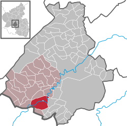
Hoppstädten-Weiersbach is an Ortsgemeinde – a municipality belonging to a Verbandsgemeinde, a kind of collective municipality – in the Birkenfeld district in Rhineland-Palatinate, Germany. It belongs to the Verbandsgemeinde of Birkenfeld, whose seat is in the like-named town.
The municipality lies in neither the Hunsrück nor the Palatinate, but rather near the boundary with the Saarland in the Nahe valley in the Upper Nahe Uplands (Oberes Nahebergland), part of the Saar-Nahe Hills (Saar-Nahe-Bergland). The countryside and the municipality itself are characterized by the Hoppstädt Nahe valley, a broad floodplain with vast meadowlands and wooded mountain slopes on both sides. These mountains are known as the Hoppstädter Berg and the Weiersbacher Berg. Lying higher up are great cropfields. Many parts of the Nahe valley between Hoppstädten-Weiersbach and Idar-Oberstein have been left in their natural state and, accordingly, in 1991, parts of it were declared a scenic conservation area (Landschaftsschutzgebiet).
Hoppstädten-Weiersbach’s Ortsteile are Hoppstädten, Weiersbach (with Bleiderdingen) and Neubrücke.
In the Middle Ages, the villages of Weiersbach and Hoppstädten, along with Leitzweiler, Heimbach and Freisen, belonged to the lordship of Werdenstein. It was a sideline of the Lords of Oberstein who first named themselves Werdenstein, after the lordship. Jakob von Eberstein married the daughter who held hereditary rights, and about 1550 he built the castle that bore the same name. It stood between the municipality’s two main centres and had been completely dismantled by the early 19th century.
...
Wikipedia


