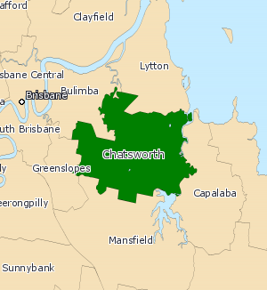
Electoral district of Chatsworth
|
Chatsworth Queensland—Legislative Assembly |
|
|---|---|

Chatsworth (2008—)
|
|
| State | Queensland |
| Dates current | 1960–present |
| MP | Steve Minnikin |
| Party | Liberal National |
| Namesake | Chatsworth Road |
| Electors | 34,653 (2015) |
| Area | 61 km2 (23.6 sq mi) |
| Coordinates | 27°30′S 153°8′E / 27.500°S 153.133°ECoordinates: 27°30′S 153°8′E / 27.500°S 153.133°E |
Chatsworth is an electoral district of the Legislative Assembly in the Australian state of Queensland. The electorate is centred on the south-eastern suburbs of Brisbane and stretches north to Tingalpa, west to Carina Heights, east to Tingalpa Creek and south to Bulimba Creek.
Unusually for a suburban seat, the district of Chatsworth is not named after a suburb within its boundaries but is instead named after Chatsworth Road. This even though Chatsworth Road does not fall within the present district of Chatsworth; it runs through the neighbouring district of Greenslopes.
...
Wikipedia
