Tingalpa, Queensland
|
Tingalpa Brisbane, Queensland |
|||||||||||||
|---|---|---|---|---|---|---|---|---|---|---|---|---|---|

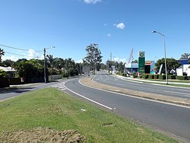
Wynnum Road, 2015
|
|||||||||||||
| Population | 8,539 (2011 census) | ||||||||||||
| Postcode(s) | 4173 | ||||||||||||
| Location | 10 km (6 mi) E of Brisbane CBD | ||||||||||||
| LGA(s) |
City of Brisbane (Doboy Ward) |
||||||||||||
| State electorate(s) | Chatsworth | ||||||||||||
| Federal Division(s) | Bonner | ||||||||||||
|
|||||||||||||
Tingalpa is a suburb of Brisbane, Queensland, Australia. It is located 10 kilometres (6.2 mi) east of the CBD, and borders Belmont, Cannon Hill, Hemmant, and Manly West.
The suburb has some older style homes built in the post war period – weatherboard and chamferboard post war cottages in particular. Most of the new estates are made up of typically low set and high set brick and tile homes. Previously the land that is now being developed into residential zones was devoted to small farmlets and semi-industrial developments.
The recent developments, which occurred in the last five years, are increasing the population and the median house prices of the suburb.
Also nearby is the Murarrie railway station that runs west to the City and east to Manly and the bay. There are also several bus routes from Tingalpa to neighbouring suburbs.
The origin of Tingalpa's name is uncertain. It may be named after Tingalpa Creek, which lies 5 kilometres (3.1 mi) east, or be derived from the Turrubal words tangul (meaning 'plant for stupefying fish') and pa (meaning 'place').
Tingalpa Creek was surveyed in 1841 and named Tingulpa, probably derived from an Aboriginal expression referring to a fat kangaroo.
In 1863, a township site was surveyed on the west side of Tingalpa Creek, where Old Cleveland Road crossed the creek. It was never built on and was known as Old Tingalpa. In 1943, this location was formally abolished. In 1860s a new site was settled called New Tingalpa, away to the north-west. In 1867, a post office was opened. In the same year a local architect, Richard Suter designed the Gothic (Anglican) Christ church. Which was built in 1868. The church and burial ground located on Wynnum rd, east of Bulimba Creek. Both the church and burial ground are heritage listed with Queensland heritage register. The Royal Mail Hotel was licensed in 1870. This hotel is now named the Tingalpa Hotel. The Tingalpa primary school was opened in 1873. In 1880, a local government division was established for the Tingalpa area. The boundaries of this area are "south-east from the intersection of the Pacific Highway and the Mount Gravatt-Capalaba Road, crossing the Tingalpa Creek and ending at Redland Bay." At Mount Cotton the headquarters of the local government were located.
...
Wikipedia
