Eldorado, Texas
| Eldorado, Texas | |
|---|---|
| City | |

Eldorado welcome sign
|
|
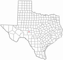
 Location of Eldorado, Texas |
|
 |
|
| Coordinates: 30°51′39″N 100°35′54″W / 30.86083°N 100.59833°WCoordinates: 30°51′39″N 100°35′54″W / 30.86083°N 100.59833°W | |
| Country | United States |
| State | Texas |
| County | Schleicher |
| Government | |
| • Type | Mayor–council |
| • Body | City Council |
| • Mayor | John Nikolauk |
| Area | |
| • Total | 1.4 sq mi (3.6 km2) |
| • Land | 1.4 sq mi (3.6 km2) |
| • Water | 0.0 sq mi (0.0 km2) |
| Elevation | 2,438 ft (743 m) |
| Population (2010) | |
| • Total | 1,951 |
| • Density | 1,400/sq mi (540/km2) |
| Time zone | Central (CST) (UTC-6) |
| • Summer (DST) | CDT (UTC-5) |
| ZIP code | 76936 |
| Area code(s) | 325 |
| FIPS code | 48-22960 |
| GNIS feature ID | 1356891 |
Eldorado (/ˌɛldəˈreɪdoʊ/ ELL-də-RAY-doh) is a city in and the county seat of Schleicher County, Texas, United States. The population was 1,951 at the 2010 census. Eldorado is located on U.S. Highway 277 some 21 miles (34 km) north of Sonora and 43 miles (69 km) south of San Angelo, Texas.
Eldorado is located at 30°51′39″N 100°35′54″W / 30.86083°N 100.59833°W (30.860746, −100.598329).
According to the United States Census Bureau, the city has a total area of 1.4 square miles (3.6 km²), all of it land.
As of the census of 2000, 1,951 people, 712 households, and 513 families resided in the city. The population density was 1,407.5 people per square mile (541.9/km²). There were 838 housing units at an average density of 604.6 per square mile (232.8/km²). The racial makeup of the city was 70.63% White, 2.15% African American, 0.10% Native American, 0.26% Asian, 0.05% Pacific Islander, 24.24% from other races, and 2.56% from two or more races. Hispanics or Latinos of any race were 53.92% of the population.
...
Wikipedia
