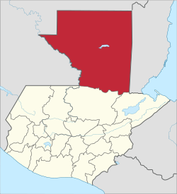
El Peten
| El Petén | |||
|---|---|---|---|
| Department | |||
|
|||
 El Petén |
|||
| Coordinates: 16°54′N 89°54′W / 16.900°N 89.900°WCoordinates: 16°54′N 89°54′W / 16.900°N 89.900°W | |||
| Country |
|
||
| Department | El Petén | ||
| Capital | Flores | ||
| Municipalities | 12 | ||
| Government | |||
| • Type | Departmental | ||
| Area | |||
| • Department | 35,854 km2 (13,843 sq mi) | ||
| Population (Census 2002) | |||
| • Department | 366,735 | ||
| • Urban | 110,399 | ||
| • Ethnicities | Ladino, Mopan, Lacandon, Itza, Q'eqchi' | ||
| • Religions | Roman Catholicism, Evangelicalism | ||
| Time zone | -6 | ||
| ISO 3166 code | GT-PE | ||
Petén is a department of the nation of Guatemala. It is geographically the northernmost department of Guatemala, as well as the largest in size — at 13,843 sq mi (35,854 km2) it accounts for about one third of Guatemala's area. The capital is Flores. The population at the 2002 Census was 366,735; the latest official estimate as at mid-2012 was 662,779.
The Petén department is bordered on the east by Belize and by Mexico on the north and west, with the Mexican state of Chiapas to the west, Tabasco to the northwest and Campeche to the north. To the south it borders the Guatemalan departments of Alta Verapaz and Izabal. Much of the western border with Mexico is formed by the Usumacinta River and its tributary the Salinas River. Portions of the southern border of the department are formed by the rivers Gracias a Dios and Santa Isabel.
The Petén lowlands are formed by a densely forested low-lying limestone plain featuring karstic topography. The area is crossed by low east-west oriented ridges of Cenozoic limestone and is characterised by a variety of forest and soil types; water sources include generally small rivers and low-lying seasonal swamps known as bajos. A chain of fourteen lakes runs across the central drainage basin of the Petén; during the rainy season some of these lakes become interconnected. This drainage area measures approximately 100 kilometres (62 mi) east-west by 30 kilometres (19 mi) north-south. The largest lake is Lake Petén Itza, near the centre of the drainage basin; it measures 32 by 5 kilometres (19.9 by 3.1 mi). A broad savannah extends south of the central lakes; it features a compact red clay soil that is too poor to support heavy cultivation. This resulted in a relatively low level of pre-Columbian occupation. The savannah has an average altitude of 150 metres (490 ft) above mean sea level with karstic ridges reaching an average altitude of 300 metres (980 ft). The savannah is surrounded by hills with unusually steep southern slopes and gentler northern approaches; the hills are covered with dense tropical forest. To the north of the lakes region bajos become more frequent, interspersed with forest. In the far north of the Petén the Mirador Basin forms another interior drainage region. To the south Petén reaches an altitude of approximately 500 metres (1,600 ft) as it rises towards the Guatemalan Highlands and meets Paleozoic metamorphic rocks.
...
Wikipedia


