El Granada, California
| El Granada | |
|---|---|
| census-designated place | |

El Granada panoramio
|
|
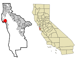
 Location in San Mateo County and the state of California |
|
| Location in the United States | |
| Coordinates: 37°30′14″N 122°28′24″W / 37.50389°N 122.47333°WCoordinates: 37°30′14″N 122°28′24″W / 37.50389°N 122.47333°W | |
| Country |
|
| State |
|
| County | San Mateo |
| Area | |
| • Total | 4.822 sq mi (12.489 km2) |
| • Land | 4.822 sq mi (12.489 km2) |
| • Water | 0 sq mi (0 km2) 0% |
| Elevation | 39 ft (12 m) |
| Population (2010) | |
| • Total | 5,467 |
| • Density | 1,100/sq mi (440/km2) |
| Time zone | PST (UTC-8) |
| • Summer (DST) | PDT (UTC-7) |
| ZIP code | 94018 |
| Area code(s) | 650 |
| FIPS code | 06-21936 |
| GNIS feature ID | 1659720 |
El Granada is a census-designated place (CDP) in the coastal area of northern San Mateo County, California, United States. The population was 5,467 at the 2010 census.
El Granada is located at 37°30′14″N 122°28′24″W / 37.50389°N 122.47333°W (37.503766, -122.473230), on the less densely populated Pacific coast side of San Mateo County, approximately 25 miles (40 km) south of San Francisco and 45 miles (72 km) north of Santa Cruz, California. Neighboring towns include Montara and Moss Beach to the north and Half Moon Bay to the south.
According to the United States Census Bureau, the CDP has a total area of 4.8 square miles (12 km2), all of it land.
The 2010 United States Census reported that El Granada had a population of 5,467. The population density was 1,133.7 people per square mile (437.7/km²). The racial makeup of El Granada was 4,608 (84.3%) White, 45 (0.8%) African American, 38 (0.7%) Native American, 190 (3.5%) Asian, 5 (0.1%) Pacific Islander, 336 (6.1%) from other races, and 245 (4.5%) from two or more races. Hispanic or Latino of any race were 813 persons (14.9%).
...
Wikipedia

