Montara, California
| Montara | |
|---|---|
| census-designated place | |

Montara State Beach in Montara
|
|
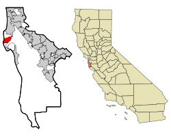
 Location in San Mateo County and the state of California |
|
| Location in the United States | |
| Coordinates: 37°32′23″N 122°30′23″W / 37.53972°N 122.50639°WCoordinates: 37°32′23″N 122°30′23″W / 37.53972°N 122.50639°W | |
| Country |
|
| State |
|
| County | San Mateo |
| Area | |
| • Total | 3.878 sq mi (10.045 km2) |
| • Land | 3.878 sq mi (10.045 km2) |
| • Water | 0 sq mi (0 km2) 0% |
| Elevation | 98 ft (30 m) |
| Population (2010) | |
| • Total | 2,909 |
| • Density | 750/sq mi (290/km2) |
| Time zone | PST (UTC-8) |
| • Summer (DST) | PDT (UTC-7) |
| ZIP code | 94037 |
| Area code(s) | 650 |
| FIPS code | 06-48760 |
| GNIS feature ID | 0277558 |
Montara is a census-designated place (CDP) in San Mateo County, California, United States. The population was 2,909 at the 2010 census. Nearby communities include Moss Beach and Princeton-by-the-Sea.
According to historical sources, the name "Montoro" was initially used for Montara Mountain and Montara Point by the Whitney Survey, also known as the California Geological Survey, in 1867. In 1869, the Coast Survey referred to the area with its current name. The name is thought to be a misspelling of several Spanish words that describe mountains and forests, such as montuoso, montaraz, and montaña. It could also refer to a corruption of the Spanish word "Montosa"; "Cañada Montosa" (valley of brush) was allegedly written on an 1838 design of Rancho San Pedro, located in Southern California, but the connections between this plan and the town are unclear.
Montara is located at 37°32′23″N 122°30′23″W / 37.53972°N 122.50639°W (37.539639, -122.506426), approximately 20 miles (32 km) south of San Francisco and 50 miles (80 km) north of Santa Cruz, California. Neighboring towns include Pacifica to the north, Moss Beach, El Granada, and Half Moon Bay to the south. According to the United States Census Bureau, the CDP has a total area of 3.9 square miles (10 km2), all of it land.
...
Wikipedia

