El Dorado Hills, California
| El Dorado Hills | |
|---|---|
| Census designated place | |
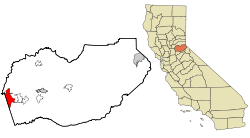
 Location in El Dorado County and the state of California |
|
 Map of El Dorado Hills and surrounding region |
|
| Location in the United States | |
| Coordinates: 38°41′09″N 121°04′56″W / 38.68583°N 121.08222°WCoordinates: 38°41′09″N 121°04′56″W / 38.68583°N 121.08222°W | |
| Country |
|
| State |
|
| County | El Dorado |
| Area | |
| • Total | 48.606 sq mi (125.888 km2) |
| • Land | 48.454 sq mi (125.494 km2) |
| • Water | 0.152 sq mi (0.394 km2) 0.31% |
| Elevation | 768 ft (234 m) |
| Population (April 1, 2010) | |
| • Total | 42,108 |
| • Density | 870/sq mi (330/km2) |
| Time zone | Pacific (UTC-8) |
| • Summer (DST) | PDT (UTC-7) |
| ZIP code | 95762 |
| Area codes | 916, 530 |
| FIPS code | 06-21880 |
| GNIS feature IDs | 1867020, 2408055 |
El Dorado Hills (EDH) is an unincorporated census-designated place (CDP) located in El Dorado County, California, 22 miles (35 km) east of the state capital of Sacramento. The population was 42,108 at the 2010 census, up from 18,016 at the 2000 census. This population growth is attributed through the combination of actual population increase within the 2000 CDP boundaries and expansion of the boundaries. The area of EDH was expanded from 17.9 square miles (46 km2) in 2000 to 48.606 square miles (125.89 km2) in 2010.
El Dorado Hills residents and businesses are most closely affiliated with El Dorado County, a generally rural area. However, El Dorado County is part of the Sacramento Metropolitan Area because it is socially and economically integrated with the much larger Sacramento County and especially the City of Folsom. El Dorado Hills is recognized nationally for its high median household income, ranking 77th in CNN Money Magazine's best places to live in 2007, with the median household income for 2007 over $115,000.
El Dorado Hills lies about 18.6 miles from the 1848 gold find site in Coloma, the impetus for the California Gold Rush. Gold was washed down the South Fork of the American River, into areas now in El Dorado Hills and Folsom, but farming and ranching supplanted the Gold Rush. Portions of two Pony Express routes in this area from 1860-1861 remain as modern El Dorado Hills roads. El Dorado Hills includes the longest surviving section of the Lincoln Highway, the first U.S. transcontinental highway. This section, part of the Pioneer Branch, passes through historic Clarksville and is the predecessor of the modern US 50 route.
The modern history of El Dorado Hills dates back to the early 1960s when original developer Alan Lindsey began its development as a master planned community. The original master plan, prepared by architect Victor Gruen, covered the area generally north of U.S. Highway 50, and part of the area south of US 50 now considered to be part of the community. El Dorado Hills was envisioned as a large-scale master-planned community that would be completely planned from its inception as a group of residential "villages". Other land uses in the master plan included a business park, 18-hole golf course, community parks, schools, a community shopping center, and small commercial centers in each village. The master plan emphasized open space between villages and opportunity for outdoor recreation.
...
Wikipedia

