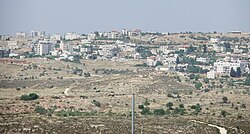
Ein Yabrud
| Ein Yabrud | |
|---|---|
| Other transcription(s) | |
| • Arabic | عين يبرود |
| • Also spelled | 'Ein Yabrud (official) Ayn Yabrood (unofficial) |
 |
|
| Location of Ein Yabrud within the Palestinian territories | |
| Coordinates: 31°56′51″N 35°14′55″E / 31.94750°N 35.24861°ECoordinates: 31°56′51″N 35°14′55″E / 31.94750°N 35.24861°E | |
| Governorate | Ramallah & al-Bireh |
| Government | |
| • Type | Municipality |
| • Head of Municipality | Awni Hasan Sha'ib |
| Area | |
| • Jurisdiction | 11,488 dunams (11.5 km2 or 4.4 sq mi) |
| Population (2007) | |
| • Jurisdiction | 3,000 |
Ein Yabrud (Arabic: عين يبرود) is a Palestinian town in the Ramallah and al-Bireh Governorate in the central West Bank. It is located approximately 7 km northeast of the city of Ramallah and its elevation is 800 m. According to a census conducted in 1931 by the British Mandate authorities, Ein Yabrud had a population of 788 inhabitants, in 178 houses. According to the Palestinian Central Bureau of Statistics (PCBS) the town had a population of 3,000 in 2007. It is the home village of Hamas military commander Maher Udda.
Jordan confiscated lands of Ein Yabrud and nearby Silwad for the construction of a military camp before the Six Day War. The Jordanian buildings formed the initial basis of the Israeli settlement of Ofra founded in 1975. Plans for further expansion of Ofra in this land in 2011 resulted in legal challenges and public dispute. Land belonging to the residents of the village has been used to construct hundreds of structures in the neighbouring Israeli settlement of Ofra.
...
Wikipedia

