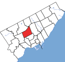
Eglinton-Lawrence
|
|
|||
|---|---|---|---|

Eglinton—Lawrence in relation to other electoral districts in Toronto (2015 boundaries)
|
|||
| Federal electoral district | |||
| Legislature | House of Commons | ||
| MP |
Liberal |
||
| District created | 1976 | ||
| First contested | 1979 | ||
| Last contested | 2015 | ||
| District webpage | profile, map | ||
| Demographics | |||
| Population (2011) | 113,150 | ||
| Electors (2015) | 76,739 | ||
| Area (km²) | 22.67 | ||
| Pop. density (per km²) | 4,991.2 | ||
| Census divisions | Toronto | ||
| Census subdivisions | Toronto | ||
Eglinton—Lawrence is a federal electoral district in Ontario, Canada, that has been represented in the House of Commons of Canada since 1979.
It covers a portion of Toronto northwest of downtown. It stretches from Yonge Street in the east to Caledonia in the west and from Highway 401 in the north to Eglinton Avenue in the south. Lawrence Avenue runs through the centre of the riding. Neighbourhoods in the riding include Bedford Park, Lawrence Manor, Lawrence Heights, the southwestern part of York Mills and the western part of Lawrence Park. The riding includes portions of the former cities of North York, Toronto, and York.
The riding was created in 1976 from parts of Eglinton, York Centre, York South, and York West. Federally, it was represented by Liberal Joe Volpe from 1988 to 2011, by Conservative Joe Oliver from 2011 to 2015, and by Liberal Marco Mendicino since the 2015 federal election.
This riding's boundaries were not changed during the 2012 electoral redistribution.
...
Wikipedia
