Eglinton—Lawrence (provincial electoral district)
|
|
|||
|---|---|---|---|

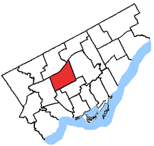
Eglinton—Lawrence in relation to other Toronto electoral districts
|
|||
| Provincial electoral district | |||
| Legislature | Legislative Assembly of Ontario | ||
| MPP |
Liberal |
||
| District created | 1999 | ||
| First contested | 1999 | ||
| Last contested | 2014 | ||
| Demographics | |||
| Population (2011) | 113,150 | ||
| Electors (2007) | 72,202 | ||
| Area (km²) | 22.67 | ||
| Pop. density (per km²) | 4,991.2 | ||
| Census divisions | Toronto | ||
| Census subdivisions | Toronto | ||
Eglinton—Lawrence is a provincial electoral district in Toronto, Ontario, Canada. It elects one member to the Legislative Assembly of Ontario.
It was created in 1999 from parts of Lawrence, York Mills, Wilson Heights, Oakwood, St. Andrew—St. Patrick and Eglinton.
When the riding was created, it included all of Metro Toronto within the following line: Highway 401 to the CN Railway to Eglinton Avenue to Dufferin Street to Rogers Road to Oakwood Avenue to Holland Park Avenue to Winona Drive to the border of Old Toronto to Bathurst Street to the Belt Line to Eglinton Avenue to Yonge Street.
In 2007, the southern border was altered so that it was Eglinton Avenue from the CN Railway to Yonge Street.
Coordinates: 43°43′03″N 79°26′54″W / 43.7175°N 79.4483°W
...
Wikipedia
