Edmonton City Centre Airport
| Edmonton City Centre Airport Blatchford Field |
|||||||||||||||
|---|---|---|---|---|---|---|---|---|---|---|---|---|---|---|---|

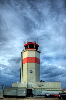
City Centre Airport control tower in 2010
|
|||||||||||||||
| Summary | |||||||||||||||
| Airport type | Public | ||||||||||||||
| Owner | City of Edmonton | ||||||||||||||
| Operator | Edmonton Airports | ||||||||||||||
| Serves | Edmonton, Alberta | ||||||||||||||
| Opened | 1927 | ||||||||||||||
| Closed | November 30, 2013 | ||||||||||||||
| Time zone | MST (UTC−07:00) | ||||||||||||||
| • Summer (DST) | MDT (UTC−06:00) | ||||||||||||||
| Elevation AMSL | 2,202 ft / 671 m | ||||||||||||||
| Coordinates | 53°34′19″N 113°31′10″W / 53.57194°N 113.51944°WCoordinates: 53°34′19″N 113°31′10″W / 53.57194°N 113.51944°W | ||||||||||||||
| Map | |||||||||||||||
| Location within Edmonton | |||||||||||||||
| Runways | |||||||||||||||
|
|||||||||||||||
| Statistics (2012) | |||||||||||||||
|
|||||||||||||||
| Aircraft Movements | 55,863 |
|---|
Edmonton City Centre (Blatchford Field) Airport (ECCA), (IATA: YXD, ICAO: CYXD), was located within the city of Edmonton, Alberta, Canada. It was bordered by Yellowhead Trail to the north, Kingsway to the south, 121 Street to the west, and the Northern Alberta Institute of Technology (NAIT) and Jefferson armouries to the east. It encompassed approximately 144 acres (58 ha) of land just north of the Edmonton city centre. The airport was originally named for former mayor Kenneth Alexander Blatchford, then was known as the Edmonton Municipal Airport, then as Edmonton Industrial Airport and then as Edmonton City Centre Airport, finally ending as Blatchford Field at Edmonton City Centre Airport. In all cases, the three letter "YXD" code continued to be used for the airport by all of the airlines serving the airfield over the years.
The airport was closed in November 2013 and has been redeveloped for housing.
The airport has a rich aviation history, being the first licensed airfield in Canada (1929). Characters such as Wop May helped pioneer aviation in Alberta and Northern Canada, further solidifying Blatchford Field as the "Gateway to the North". Wiley Post landed there during both of his circumnavigations. The airport was also former military airbase serving as a major stop-over on the Northwest Staging Route during World War II and hosted a wartime British Commonwealth Air Training Plan flying school as well as an air observer school. A full history can be gathered at the Alberta Aviation Museum.
...
Wikipedia

