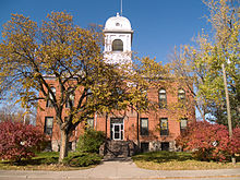
Eddy County, North Dakota
| Eddy County, North Dakota | |
|---|---|

|
|
 Location in the U.S. state of North Dakota |
|
 North Dakota's location in the U.S. |
|
| Founded | April 27, 1885 |
| Seat | New Rockford |
| Largest city | New Rockford |
| Area | |
| • Total | 644 sq mi (1,668 km2) |
| • Land | 630 sq mi (1,632 km2) |
| • Water | 14 sq mi (36 km2), 2.2% |
| Population (est.) | |
| • (2015) | 2,365 |
| • Density | 3.8/sq mi (1/km²) |
| Congressional district | At-large |
| Time zone | Central: UTC-6/-5 |
| Website | Eddy County, North Dakota |
Eddy County is a county located in the U.S. state of North Dakota. As of the 2010 census, the population was 2,385. Its county seat is New Rockford. Eddy County was created by the 1885 territorial legislature from the northern half of Foster County and named for Ezra B. Eddy, a Fargo banker who had died a few weeks earlier. The county government was first organized on April 27, 1885.
Eddy County was formed in 1885 from a portion of Foster County. It was named after Ezra B. Eddy, one of the first bankers of the region in Fargo.
According to the U.S. Census Bureau, the county has a total area of 644 square miles (1,670 km2), of which 630 square miles (1,600 km2) is land and 14 square miles (36 km2) (2.2%) is water. It is the smallest county in North Dakota by area.
Eddy County Road 14 is a north-south County Road in North Dakota. It runs from North Dakota Highway 15 near New Rockford, North Dakota to Eddy County Road 9 (1st Ave North) in downtown New Rockford.
Eddy County Road 9 is an East-West County Road in North Dakota. It runs from US 281/North Dakota Highway 15 (1st Street) in New Rockford, North Dakota to Wells County CR 2 near New Rockford.
...
Wikipedia
